|
|
| PO BOX 275 |
|
| SARATOGA , NC 27873-0275 |
|
| Property
Location Address |
|
| Parcel
ID No. |
3669449407.000 |
| PIN |
3669 44 9407 000 |
| Owner ID |
97886350 |
| |
|
| Tax
District |
9 - C/CISA-SARATOGA |
| |
| Land Use Code |
10 |
| Land Use Desc |
COMMERICAL |
| |
|
| Neighborhood |
8259 - SARATOGA_GB |
|
| Legal
Desc |
7021 MAIN ST |
| |
MOORE LD 2.37AC |
| |
|
| Deed
Year Bk/Pg |
2014 - 2590 / 844 |
| Plat
Bk/Pg |
/ |
| |
Sales
Information |
| |
| Grantor |
WALSTON MARVIN STANLEY |
| |
WALSTON CAROLYN F |
| Sold
Date |
2014-10-08 |
| Sold
Amount $ |
30,000 |
|
| |
| Market Value $ |
94,416
|
| |
|
Market
Value - Land and all permanent improvements,
if any, effective January 1, 2024, date
of County’s most recent General Reappraisal
|
|
| |
|
| Assessed Value $ |
94,416
|
| |
If
Assessed Value not equal Market Value then
subject parcel designated as a special
class -agricultural, horticultural, or
forestland and thereby eligible for taxation
on basis of Present-Use.
|
|
|
| Year
Built |
1950 |
| Built
Use/Style |
COMMERCIAL |
| Grade |
C-10 / C-10 GRADE |
| * Percent
Complete |
100 |
| Heated
Area (S/F) |
2,100 |
| Fireplace
(Y/N) |
N |
| Basement
(Y/N) |
N |
| ** Bedroom(s) |
0 |
| ** Bathroom(s) |
0 Full Bath(s) 0 Half Bath(s) |
| *** Multiple
Improvements |
001 |
*
Note - As of January 1
*
* Note - Bathroom(s), Bedroom(s), shown for description
only
* * * Note - If multiple improvements equal “MLT” then
parcel includes additional major improvements |
|
| Photo |
Photo 1
 Photo 2

|
|
| Building
Sketch - NOTE: Sketches are updated the first day of every month. |
|
(Building 1) - Sketch for Parcel ID: 3669449407.000
NOTE: Sketches are updated the first day of every month.
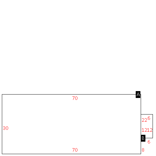 |
| Label |
Description |
Base SF |
Total SF |
| A |
COMMERCIAL-MISC |
2100.00 |
2100.00 |
| B |
STOOP-MAS |
72.00 |
.00 |
|
|
|
|
|
| Map Acres |
2.37 |
| Tax District Note |
9 - C/CISA-SARATOGA |
| Present-Use Info |
COMMERICAL |
| Zoning Code |
GB |
| Zoning Desc |
GENERAL BUSINESS |
|
| Total Improvements Valuation
|
*Total Improvements Full Market Value $
|
**Total Improvements Assessed Value
|
32,474
|
32,474
|
*
Note - Market Value effective Date equal January 1, 2024, date of County’s most recent General
Reappraisal
** Note - If Assessed Value not equal Market Value then variance
resulting from formal appeal procedure |
|
| Land
Value Detail (Effective Date January 1, 2024, date
of County’s most recent General Reappraisal) |
Land
Full Value (LFV) $
|
Land
Present-Use Value (PUV) $ **
|
Land
Total Assessed Value $
|
61,942
|
61,942
|
61,942
|
| **
Note: If PUV equal LMV then parcel has
not qualified for present use program |
|
| Land
Detail (Effective Date January 1, 2024, date of County’s
most recent General Reappraisal) |
Rate Type |
Rate Code |
Description |
Quantity |
SF |
0700 |
COMMERCIAL |
103237.000 |
|
|
|
.000 |
|
|
|
|
