|
|
| PO BOX 108 |
|
| HENDERSON , NC 27536 |
|
| Property
Location Address |
|
| Parcel
ID No. |
2793637014.000 |
| PIN |
2793 63 7014 000 |
| Previous Parcel |
2793637014.NPN |
| Owner ID |
69957367 |
| |
|
| Tax
District |
31 - C/CIWI-WILSON |
| |
| Land Use Code |
10 |
| Land Use Desc |
COMMERICAL |
| |
|
| Neighborhood |
8248 - RALEIGH_ROAD_PKWY-I_95_B- |
|
| Legal
Desc |
4904 CASWELL PL W |
| |
L2S1 WESTGATE CENTR1.52AC |
| |
|
| Deed
Year Bk/Pg |
2007 - 2211 / 116 |
| Plat
Bk/Pg |
36 / 207 |
| |
Sales
Information |
| |
| Grantor |
|
| |
|
| Sold
Date |
0--0 |
| Sold
Amount $ |
0 |
|
| |
| Market Value $ |
1,427,925
|
| |
|
Market
Value - Land and all permanent improvements,
if any, effective January 1, 2024, date
of County’s most recent General Reappraisal
|
|
| |
|
| Assessed Value $ |
1,427,925
|
| |
If
Assessed Value not equal Market Value then
subject parcel designated as a special
class -agricultural, horticultural, or
forestland and thereby eligible for taxation
on basis of Present-Use.
|
|
|
| Year
Built |
2015 |
| Built
Use/Style |
COMMERCIAL |
| Grade |
B-10 / B-10 GRADE |
| * Percent
Complete |
100 |
| Heated
Area (S/F) |
16,200 |
| Fireplace
(Y/N) |
N |
| Basement
(Y/N) |
N |
| ** Bedroom(s) |
0 |
| ** Bathroom(s) |
0 Full Bath(s) 0 Half Bath(s) |
| *** Multiple
Improvements |
001 |
*
Note - As of January 1
*
* Note - Bathroom(s), Bedroom(s), shown for description
only
* * * Note - If multiple improvements equal “MLT” then
parcel includes additional major improvements |
|
| Photo |
|
No Photo for 2793637014.000
|
|
| Building
Sketch - NOTE: Sketches are updated the first day of every month. |
|
(Building 1) - Sketch for Parcel ID: 2793637014.000
NOTE: Sketches are updated the first day of every month.
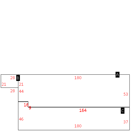 |
| Label |
Description |
Base SF |
Total SF |
| A |
COMMERCIAL-MISC |
9396.00 |
9396.00 |
| B |
CANOPY W/ SLAB |
588.00 |
.00 |
| C |
WHSE-OFFICE |
6804.00 |
6804.00 |
|
|
|
|
|
| Map Acres |
1.52 |
| Tax District Note |
31 - C/CIWI-WILSON |
| Present-Use Info |
COMMERICAL |
| Zoning Code |
LI |
| Zoning Desc |
LIGHT INDUSTRIAL |
|
| Total Improvements Valuation
|
*Total Improvements Full Market Value $
|
**Total Improvements Assessed Value
|
1,237,925
|
1,237,925
|
*
Note - Market Value effective Date equal January 1, 2024, date of County’s most recent General
Reappraisal
** Note - If Assessed Value not equal Market Value then variance
resulting from formal appeal procedure |
|
| Land
Value Detail (Effective Date January 1, 2024, date
of County’s most recent General Reappraisal) |
Land
Full Value (LFV) $
|
Land
Present-Use Value (PUV) $ **
|
Land
Total Assessed Value $
|
190,000
|
190,000
|
190,000
|
| **
Note: If PUV equal LMV then parcel has
not qualified for present use program |
|
| Land
Detail (Effective Date January 1, 2024, date of County’s
most recent General Reappraisal) |
Rate Type |
Rate Code |
Description |
Quantity |
SF |
0700 |
COMMERCIAL |
66212.000 |
|
|
|
.000 |
|
|
|
|
