| BUNN-GERRELL APRIL ELIZABETH |
| |
|
| 8430 BUNN RD |
|
| SIMS , NC 27880 |
|
| Property
Location Address |
|
| Parcel
ID No. |
2752723027.000 |
| PIN |
2752 72 3027 000 |
| Owner ID |
69956132 |
| |
|
| Tax
District |
19 - C/SW/ROCK RIDGE FD |
| |
| Land Use Code |
08 |
| Land Use Desc |
EXECPTIONAL RESIDENTIAL |
| |
|
| Neighborhood |
8219 - OLD_FIELDS |
|
| Legal
Desc |
8430 BUNN RD |
| |
BUNN LD 31.21AC |
| |
|
| Deed
Year Bk/Pg |
2006 - 2170 / 109 |
| Plat
Bk/Pg |
31 / 101 |
| |
Sales
Information |
| |
| Grantor |
|
| |
|
| Sold
Date |
0--0 |
| Sold
Amount $ |
0 |
|
| |
| Market Value $ |
882,483
|
| |
|
Market
Value - Land and all permanent improvements,
if any, effective January 1, 2024, date
of County’s most recent General Reappraisal
|
|
| |
|
| Assessed Value $ |
850,641
|
| |
If
Assessed Value not equal Market Value then
subject parcel designated as a special
class -agricultural, horticultural, or
forestland and thereby eligible for taxation
on basis of Present-Use.
|
|
|
| Year
Built |
2002 |
| Built
Use/Style |
SFR-UPTO 2.0 STY |
| Grade |
A / A GRADE |
| * Percent
Complete |
100 |
| Heated
Area (S/F) |
5,274 |
| Fireplace
(Y/N) |
Y |
| Basement
(Y/N) |
N |
| ** Bedroom(s) |
4 |
| ** Bathroom(s) |
2 Full Bath(s) 2 Half Bath(s) |
| *** Multiple
Improvements |
001 |
*
Note - As of January 1
*
* Note - Bathroom(s), Bedroom(s), shown for description
only
* * * Note - If multiple improvements equal “MLT” then
parcel includes additional major improvements |
|
| Photo |
|
No Photo for 2752723027.000
|
|
| Building
Sketch - NOTE: Sketches are updated the first day of every month. |
|
(Building 1) - Sketch for Parcel ID: 2752723027.000
NOTE: Sketches are updated the first day of every month.
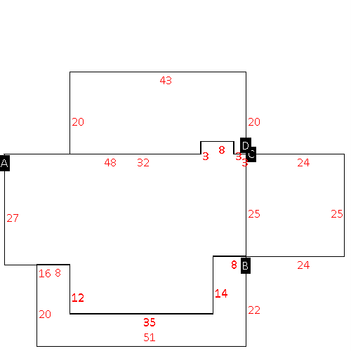 |
| Label |
Description |
Base SF |
Total SF |
| A |
SFR-EXCEPTIONAL |
2021.00 |
4183.00 |
| B |
PORCH-OPEN-MAS |
616.00 |
.00 |
| C |
GARAGE-ATT-FR |
600.00 |
.00 |
| D |
PATIO-CONC |
836.00 |
.00 |
|
|
|
|
|
| Map Acres |
31.21 |
| Tax District Note |
19 - C/SW/ROCK RIDGE FD |
| Present-Use Info |
EXECPTIONAL RESIDENTIAL |
| Zoning Code |
AR |
| Zoning Desc |
AGRICUL-RESID 40M SF |
|
| Total Improvements Valuation
|
*Total Improvements Full Market Value $
|
**Total Improvements Assessed Value
|
817,085
|
817,085
|
*
Note - Market Value effective Date equal January 1, 2024, date of County’s most recent General
Reappraisal
** Note - If Assessed Value not equal Market Value then variance
resulting from formal appeal procedure |
|
| Land
Value Detail (Effective Date January 1, 2024, date
of County’s most recent General Reappraisal) |
Land
Full Value (LFV) $
|
Land
Present-Use Value (PUV) $ **
|
Land
Total Assessed Value $
|
65,398
|
33,556
|
33,556
|
| **
Note: If PUV equal LMV then parcel has
not qualified for present use program |
|
| Land
Detail (Effective Date January 1, 2024, date of County’s
most recent General Reappraisal) |
Rate Type |
Rate Code |
Description |
Quantity |
AC |
5030 |
RURAL HOMESITE REAR NO RD |
1.000 |
|
|
|
.000 |
AC |
5313 |
MKT OPEN LD REAR CLASS 3 |
16.790 |
LU |
5320 |
|
16.790 |
AC |
5413 |
MKT OPEN LD REAR CLASS 4 |
1.610 |
LU |
5420 |
|
1.610 |
AC |
5613 |
MKT OPEN LD REAR CLASS 6 |
.780 |
LU |
5620 |
|
.780 |
AC |
6213 |
MKT WOODS REAR CLASS 2 |
4.250 |
LU |
6220 |
|
4.250 |
AC |
6413 |
MKT WOODS REAR CLASS 4 |
6.780 |
LU |
6420 |
|
6.780 |
|
|
|
|
