|
|
| 5157 BLOOMERY RD |
|
| WILSON , NC 27896-8154 |
|
| Property
Location Address |
|
| Parcel
ID No. |
2794713046.000 |
| PIN |
2794 71 3046 000 |
| Owner ID |
69954306 |
| |
|
| Tax
District |
14 - C/SW/SILVER LAKE FD |
| |
| Land Use Code |
50 |
| Land Use Desc |
RURAL HOMESITE |
| |
|
| Neighborhood |
8381 - WILSON_NORTHWEST_A-1 |
|
| Legal
Desc |
5157 BLOOMERY RD |
| |
O'NEAL LD 54.09AC |
| |
|
| Deed
Year Bk/Pg |
2023 - 2119 / 942 |
| Plat
Bk/Pg |
/ |
| |
Sales
Information |
| |
| Grantor |
|
| |
|
| Sold
Date |
0--0 |
| Sold
Amount $ |
0 |
|
| |
| Market Value $ |
252,235
|
| |
|
Market
Value - Land and all permanent improvements,
if any, effective January 1, 2024, date
of County’s most recent General Reappraisal
|
|
| |
|
| Assessed Value $ |
178,040
|
| |
If
Assessed Value not equal Market Value then
subject parcel designated as a special
class -agricultural, horticultural, or
forestland and thereby eligible for taxation
on basis of Present-Use.
|
|
|
| Year
Built |
1935 |
| Built
Use/Style |
SFR-1.0 STY |
| Grade |
D+10 / |
| * Percent
Complete |
100 |
| Heated
Area (S/F) |
1,461 |
| Fireplace
(Y/N) |
N |
| Basement
(Y/N) |
N |
| ** Bedroom(s) |
2 |
| ** Bathroom(s) |
2 Full Bath(s) 0 Half Bath(s) |
| *** Multiple
Improvements |
002 |
*
Note - As of January 1
*
* Note - Bathroom(s), Bedroom(s), shown for description
only
* * * Note - If multiple improvements equal “MLT” then
parcel includes additional major improvements |
|
| Photo |
Photo 1
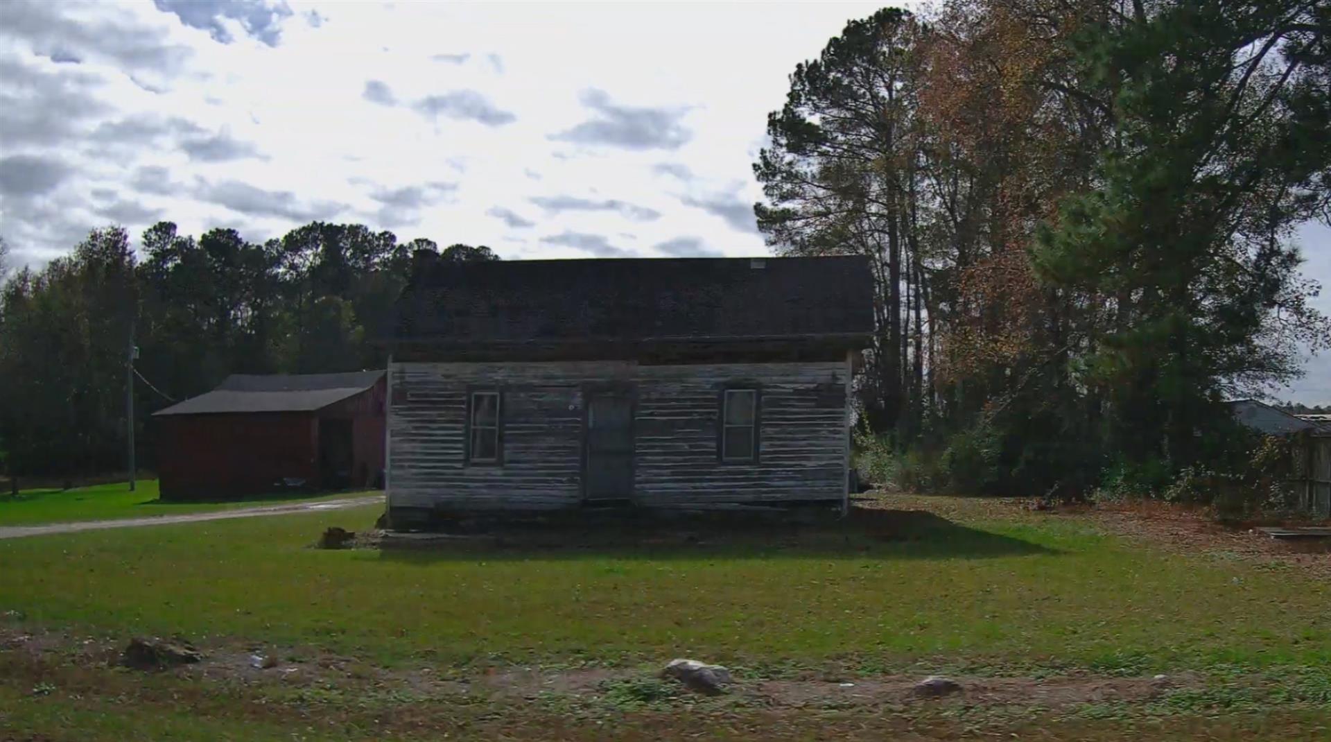 Photo 2
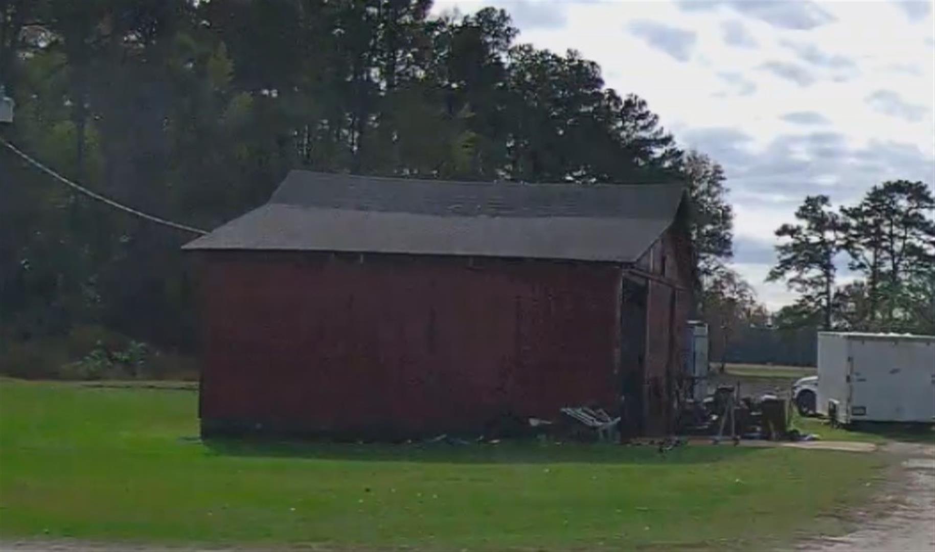 Photo 3
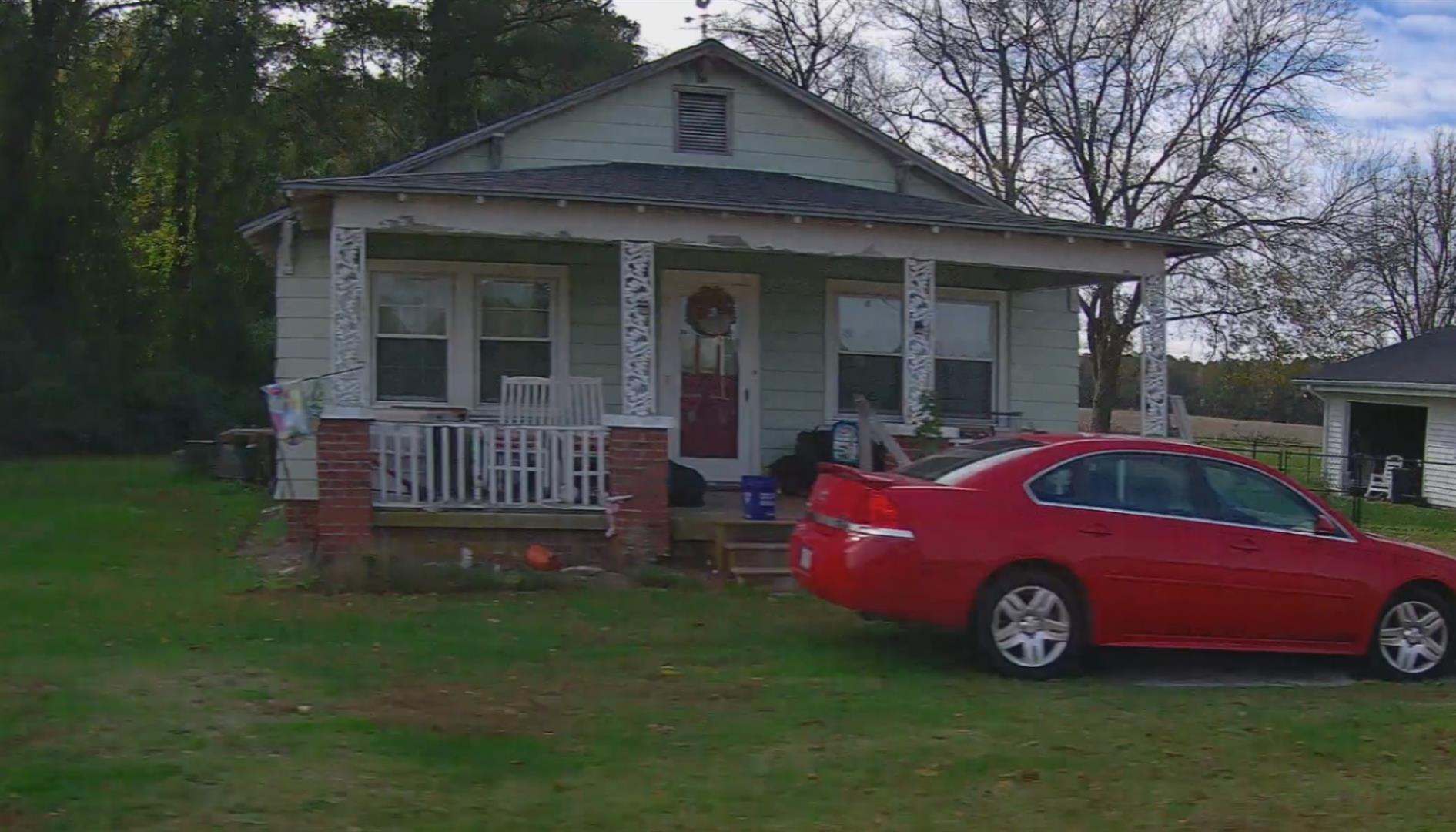 Photo 1
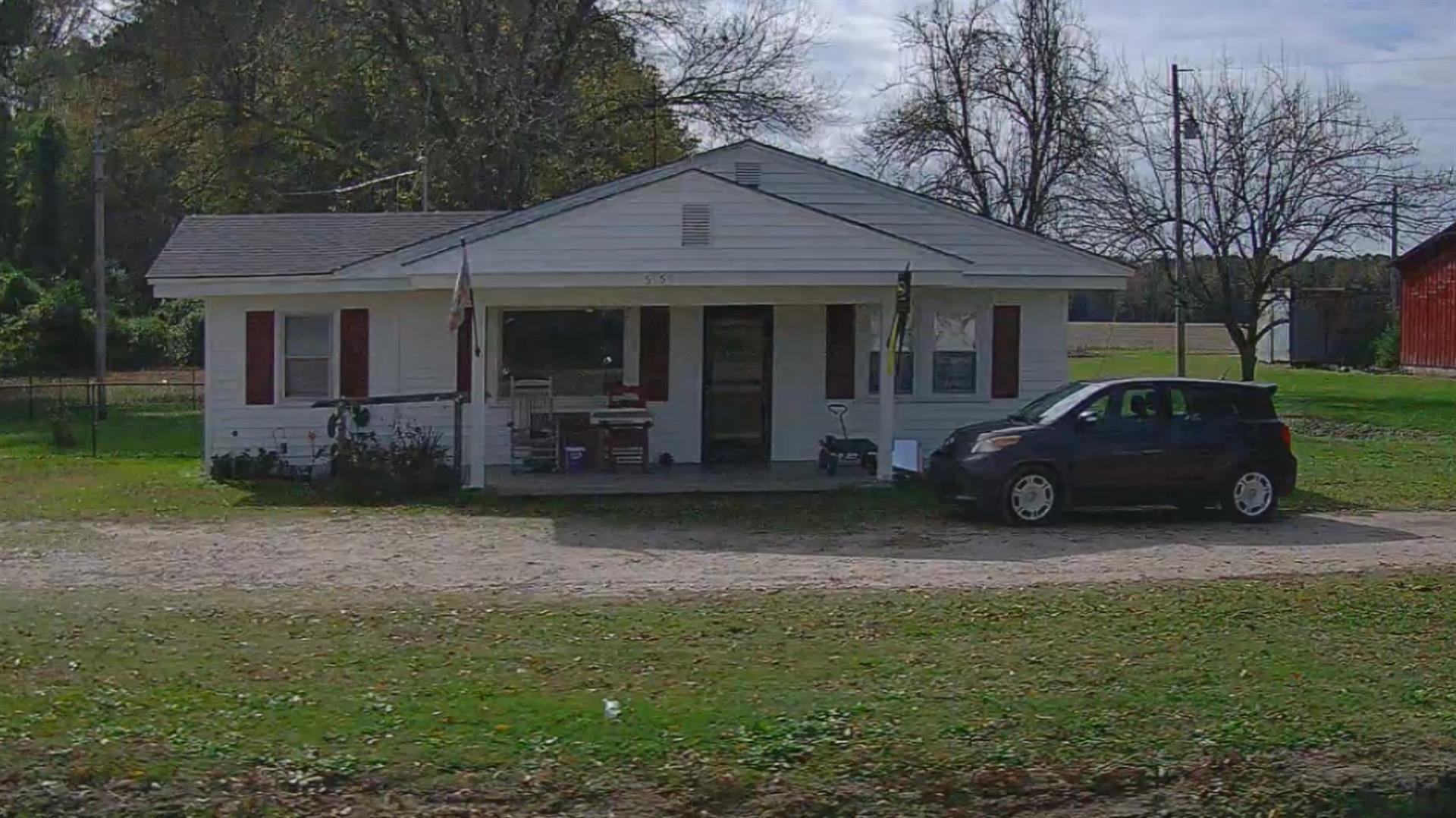 Photo 1

|
|
| Building
Sketch - NOTE: Sketches are updated the first day of every month. |
|
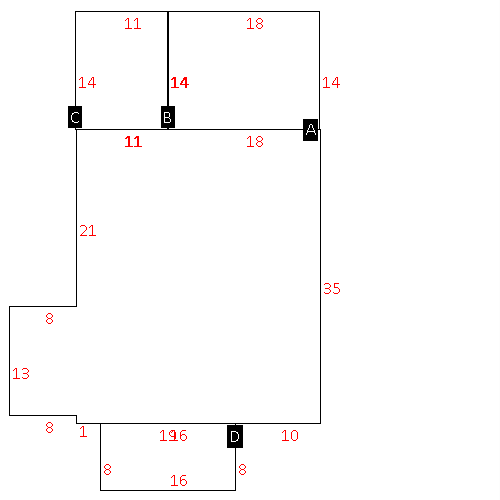
(Building 1) - Sketch for Parcel ID: 2794713046.000
NOTE: Sketches are updated the first day of every month.
 |
| Label |
Description |
Base SF |
Total SF |
| A |
SFR-1.0 STY |
1160.00 |
1160.00 |
| B |
STOOP-MAS |
16.00 |
.00 |
| C |
PORCH-OPEN-MAS |
240.00 |
.00 |
|
|
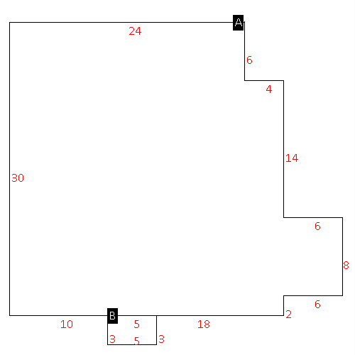
(Building 2) - Sketch for Parcel ID: 2794713046.000
NOTE: Sketches are updated the first day of every month.
 |
| Label |
Description |
Base SF |
Total SF |
| A |
SFR-1.0 STY |
1119.00 |
1119.00 |
| B |
SFR-ADDT FR |
252.00 |
252.00 |
| C |
CARPORT |
154.00 |
.00 |
| D |
PORCH-OPEN-MAS |
128.00 |
.00 |
|
|
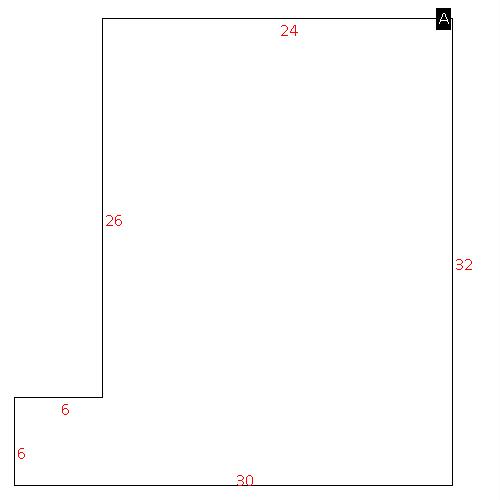
(Building 3) - Sketch for Parcel ID: 2794713046.000
NOTE: Sketches are updated the first day of every month.
 |
| Label |
Description |
Base SF |
Total SF |
| A |
SFR-1.0 STY |
864.00 |
864.00 |
| B |
PORCH-OPEN-MAS |
15.00 |
.00 |
|
|
(Building 4) - Sketch for Parcel ID: 2794713046.000
NOTE: Sketches are updated the first day of every month.
 |
| Label |
Description |
Base SF |
Total SF |
| A |
SFR-1.0 STY |
804.00 |
804.00 |
|
|
|
|
|
| Map Acres |
54.09 |
| Tax District Note |
14 - C/SW/SILVER LAKE FD |
| Present-Use Info |
RURAL HOMESITE |
| Zoning Code |
RA |
| Zoning Desc |
RESIDENTAL AGRICULTURAL |
|
| Total Improvements Valuation
|
*Total Improvements Full Market Value $
|
**Total Improvements Assessed Value
|
93,904
|
93,904
|
*
Note - Market Value effective Date equal January 1, 2024, date of County’s most recent General
Reappraisal
** Note - If Assessed Value not equal Market Value then variance
resulting from formal appeal procedure |
|
| Land
Value Detail (Effective Date January 1, 2024, date
of County’s most recent General Reappraisal) |
Land
Full Value (LFV) $
|
Land
Present-Use Value (PUV) $ **
|
Land
Total Assessed Value $
|
158,331
|
84,136
|
84,136
|
| **
Note: If PUV equal LMV then parcel has
not qualified for present use program |
|
| Land
Detail (Effective Date January 1, 2024, date of County’s
most recent General Reappraisal) |
Rate Type |
Rate Code |
Description |
Quantity |
AC |
5010 |
RURAL HOMESITE PAVED |
1.200 |
|
|
|
.000 |
AC |
5111 |
MKT OPEN LD PVD CLASS 1 |
33.870 |
LU |
5110 |
|
33.870 |
AC |
6111 |
MKT WOODS PVD CLASS 1 |
10.020 |
LU |
6110 |
|
10.020 |
AC |
6111 |
MKT WOODS PVD CLASS 1 |
9.000 |
LU |
6120 |
|
9.000 |
|
|
|
|
