| HILL MILTON DALE |
| HILL DAWN B |
|
| 7235 BATTS RD |
|
| MACCLESFIELD , NC 27852-9506 |
|
| Property
Location Address |
|
| Parcel
ID No. |
3763970712.000 |
| PIN |
3763 97 0712 000 |
| Owner ID |
69945583 |
| |
|
| Tax
District |
25 - C/SW/BAKERTOWN FD |
| |
| Land Use Code |
50 |
| Land Use Desc |
RURAL HOMESITE |
| |
|
| Neighborhood |
8121 - GARDNERS |
|
| Legal
Desc |
7235 BATTS RD |
| |
WOMBLE LD 19.72AC |
| |
|
| Deed
Year Bk/Pg |
2022 - 2946 / 784 |
| Plat
Bk/Pg |
29 / 155 |
| |
Sales
Information |
| |
| Grantor |
HILL REVOCABLE LIVING TRUST |
| |
|
| Sold
Date |
2022-02-03 |
| Sold
Amount $ |
0 |
|
| |
| Market Value $ |
900,812
|
| |
|
Market
Value - Land and all permanent improvements,
if any, effective January 1, 2024, date
of County’s most recent General Reappraisal
|
|
| |
|
| Assessed Value $ |
843,753
|
| |
If
Assessed Value not equal Market Value then
subject parcel designated as a special
class -agricultural, horticultural, or
forestland and thereby eligible for taxation
on basis of Present-Use.
|
|
|
| Year
Built |
2002 |
| Built
Use/Style |
SFR-UPTO 1.5 STY |
| Grade |
B+10 / B+10 GRADE |
| * Percent
Complete |
100 |
| Heated
Area (S/F) |
5,400 |
| Fireplace
(Y/N) |
Y |
| Basement
(Y/N) |
N |
| ** Bedroom(s) |
4 |
| ** Bathroom(s) |
4 Full Bath(s) 1 Half Bath(s) |
| *** Multiple
Improvements |
001 |
*
Note - As of January 1
*
* Note - Bathroom(s), Bedroom(s), shown for description
only
* * * Note - If multiple improvements equal “MLT” then
parcel includes additional major improvements |
|
| Photo |
|
No Photo for 3763970712.000
|
|
| Building
Sketch - NOTE: Sketches are updated the first day of every month. |
|
(Building 1) - Sketch for Parcel ID: 3763970712.000
NOTE: Sketches are updated the first day of every month.
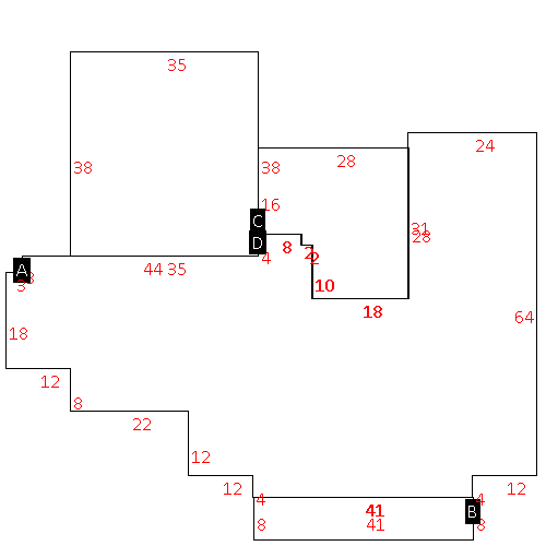 |
| Label |
Description |
Base SF |
Total SF |
| A |
SFR-1.5 STY |
4154.00 |
5400.00 |
| B |
PORCH-OPEN-MAS |
328.00 |
.00 |
| C |
PORCH-SCR-MAS |
668.00 |
.00 |
| D |
GARAGE-ATT-MAS |
1330.00 |
.00 |
|
|
|
|
|
| Map Acres |
19.72 |
| Tax District Note |
25 - C/SW/BAKERTOWN FD |
| Present-Use Info |
RURAL HOMESITE |
| Zoning Code |
AR |
| Zoning Desc |
AGRICUL-RESID 40M SF |
|
| Total Improvements Valuation
|
*Total Improvements Full Market Value $
|
**Total Improvements Assessed Value
|
811,420
|
811,420
|
*
Note - Market Value effective Date equal January 1, 2024, date of County’s most recent General
Reappraisal
** Note - If Assessed Value not equal Market Value then variance
resulting from formal appeal procedure |
|
| Land
Value Detail (Effective Date January 1, 2024, date
of County’s most recent General Reappraisal) |
Land
Full Value (LFV) $
|
Land
Present-Use Value (PUV) $ **
|
Land
Total Assessed Value $
|
89,392
|
32,333
|
32,333
|
| **
Note: If PUV equal LMV then parcel has
not qualified for present use program |
|
| Land
Detail (Effective Date January 1, 2024, date of County’s
most recent General Reappraisal) |
Rate Type |
Rate Code |
Description |
Quantity |
AC |
5010 |
RURAL HOMESITE PAVED |
1.000 |
|
|
|
.000 |
AC |
5211 |
MKT OPEN LD PVD CLASS 2 |
7.210 |
LU |
5210 |
|
7.210 |
AC |
5411 |
MKT OPEN LD PVD CLASS 4 |
4.740 |
LU |
5410 |
|
4.740 |
AC |
6211 |
MKT WOODS PVD CLASS 2 |
6.770 |
LU |
6210 |
|
6.770 |
|
|
|
|
