| TOMLINSON MARK E |
| TOMLINSON LYNDA F |
|
| 1749 B AIRPORT BLVD W |
|
| WILSON , NC 27893-9283 |
|
| Property
Location Address |
|
| Parcel
ID No. |
3702126940.000 |
| PIN |
3702 12 6940 000 |
| Owner ID |
69937755 |
| |
|
| Tax
District |
13 - C/SW/CONTENTNEA FD |
| |
| Land Use Code |
50 |
| Land Use Desc |
RURAL HOMESITE |
| |
|
| Neighborhood |
8388 - WILSON_WEST_A-1 |
|
| Legal
Desc |
1749 B AIRPORT BLVD W |
| |
12.48AC |
| |
|
| Deed
Year Bk/Pg |
2000 - 1764 / 782 |
| Plat
Bk/Pg |
/ |
| |
Sales
Information |
| |
| Grantor |
|
| |
|
| Sold
Date |
0--0 |
| Sold
Amount $ |
0 |
|
| |
| Market Value $ |
632,602
|
| |
|
Market
Value - Land and all permanent improvements,
if any, effective January 1, 2024, date
of County’s most recent General Reappraisal
|
|
| |
|
| Assessed Value $ |
619,443
|
| |
If
Assessed Value not equal Market Value then
subject parcel designated as a special
class -agricultural, horticultural, or
forestland and thereby eligible for taxation
on basis of Present-Use.
|
|
|
| Year
Built |
2000 |
| Built
Use/Style |
SFR-UPTO 1.5 STY |
| Grade |
B / |
| * Percent
Complete |
100 |
| Heated
Area (S/F) |
3,458 |
| Fireplace
(Y/N) |
Y |
| Basement
(Y/N) |
N |
| ** Bedroom(s) |
4 |
| ** Bathroom(s) |
2 Full Bath(s) 1 Half Bath(s) |
| *** Multiple
Improvements |
002 |
*
Note - As of January 1
*
* Note - Bathroom(s), Bedroom(s), shown for description
only
* * * Note - If multiple improvements equal “MLT” then
parcel includes additional major improvements |
|
| Photo |
Photo 1
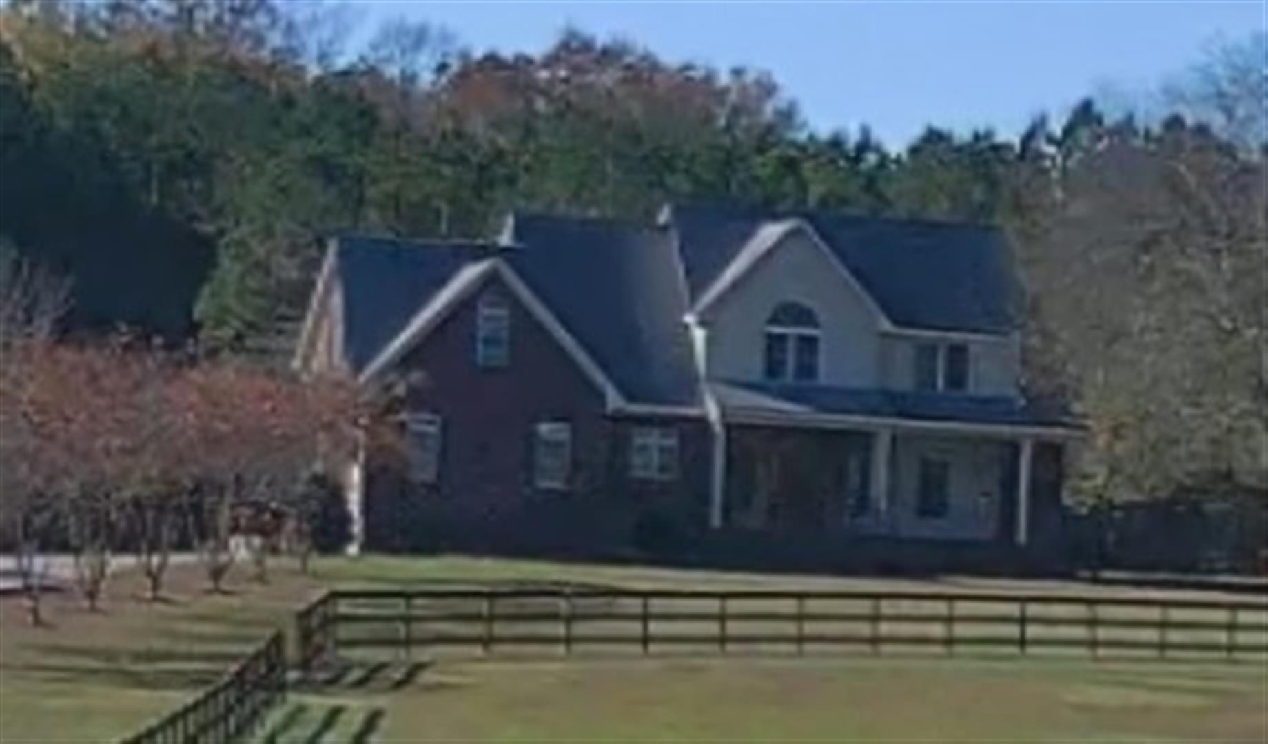
|
|
| Building
Sketch - NOTE: Sketches are updated the first day of every month. |
|
(Building 1) - Sketch for Parcel ID: 3702126940.000
NOTE: Sketches are updated the first day of every month.
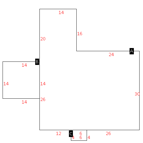 |
| Label |
Description |
Base SF |
Total SF |
| A |
SFR-1.0 STY |
1364.00 |
1364.00 |
| B |
DECK-WOOD |
196.00 |
.00 |
| C |
PORCH-OPEN-MAS |
24.00 |
.00 |
|
|
(Building 2) - Sketch for Parcel ID: 3702126940.000
NOTE: Sketches are updated the first day of every month.
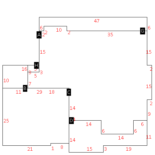 |
| Label |
Description |
Base SF |
Total SF |
| A |
SFR-1.5 STY |
1820.00 |
3458.00 |
| B |
PORCH-SCR-MAS |
125.00 |
.00 |
| C |
GARAGE-ATT-MAS |
717.00 |
.00 |
| D |
PORCH-OPEN-MAS |
335.00 |
.00 |
| G |
PORCH-OPEN-MAS |
262.00 |
.00 |
| H |
PORCH-OPEN-MAS |
15.00 |
.00 |
|
|
|
|
|
| Map Acres |
12.48 |
| Tax District Note |
13 - C/SW/CONTENTNEA FD |
| Present-Use Info |
RURAL HOMESITE |
| Zoning Code |
RA |
| Zoning Desc |
RESIDENTAL AGRICULTURAL |
|
| Total Improvements Valuation
|
*Total Improvements Full Market Value $
|
**Total Improvements Assessed Value
|
575,825
|
575,825
|
*
Note - Market Value effective Date equal January 1, 2024, date of County’s most recent General
Reappraisal
** Note - If Assessed Value not equal Market Value then variance
resulting from formal appeal procedure |
|
| Land
Value Detail (Effective Date January 1, 2024, date
of County’s most recent General Reappraisal) |
Land
Full Value (LFV) $
|
Land
Present-Use Value (PUV) $ **
|
Land
Total Assessed Value $
|
56,777
|
43,618
|
43,618
|
| **
Note: If PUV equal LMV then parcel has
not qualified for present use program |
|
| Land
Detail (Effective Date January 1, 2024, date of County’s
most recent General Reappraisal) |
Rate Type |
Rate Code |
Description |
Quantity |
AC |
5030 |
RURAL HOMESITE REAR NO RD |
2.000 |
|
|
|
.000 |
AC |
5113 |
MKT OPEN LD REAR CLASS 1 |
2.220 |
|
|
|
.000 |
AC |
5413 |
MKT OPEN LD REAR CLASS 4 |
3.480 |
LU |
5410 |
|
3.480 |
AC |
6113 |
MKT WOODS REAR CLASS 1 |
.550 |
LU |
6110 |
|
.550 |
AC |
6213 |
MKT WOODS REAR CLASS 1 |
4.230 |
LU |
6210 |
|
4.230 |
|
|
|
|
