|
|
| PO BOX 1728 |
|
| WILSON , NC 27893 |
|
| Property
Location Address |
|
| Parcel
ID No. |
3648164099.000 |
| PIN |
3648 16 4099 000 |
| Owner ID |
69913391 |
| |
|
| Tax
District |
17 - C/SW/MOYTON FD |
| |
| Land Use Code |
83 |
| Land Use Desc |
PUBLIC SCHOOLS |
| |
|
| Neighborhood |
8298 - STANTONSBURG_TWP |
|
| Legal
Desc |
5514 OLD STANTONSBURG RD |
| |
33.59AC |
| |
|
| Deed
Year Bk/Pg |
2001 - 1815 / 286 |
| Plat
Bk/Pg |
28 / 226 |
| |
Sales
Information |
| |
| Grantor |
|
| |
|
| Sold
Date |
0--0 |
| Sold
Amount $ |
0 |
|
| |
| Market Value $ |
8,662,631
|
| |
|
Market
Value - Land and all permanent improvements,
if any, effective January 1, 2024, date
of County’s most recent General Reappraisal
|
|
| |
|
| Assessed Value $ |
8,662,631
|
| |
If
Assessed Value not equal Market Value then
subject parcel designated as a special
class -agricultural, horticultural, or
forestland and thereby eligible for taxation
on basis of Present-Use.
|
|
|
| Year
Built |
2000 |
| Built
Use/Style |
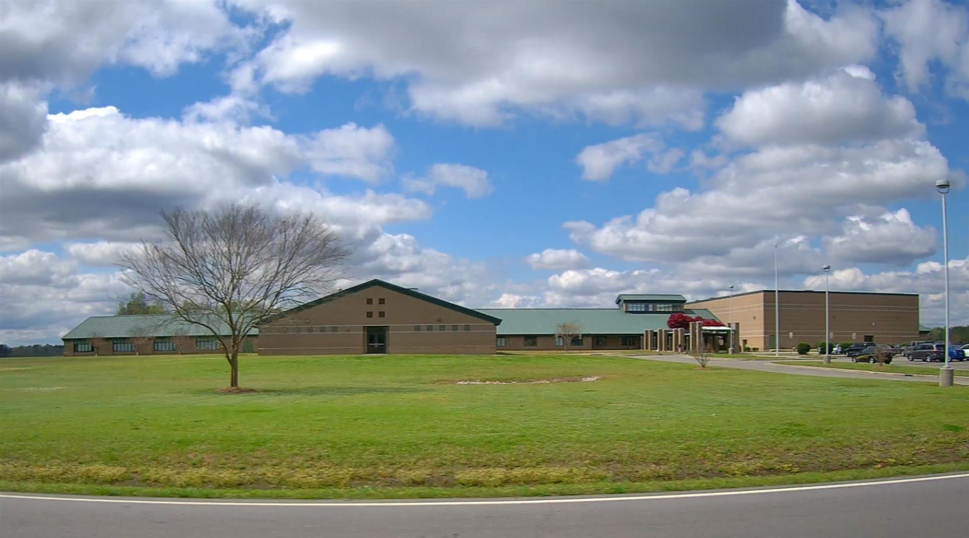
SCHOOL- PUBLIC |
| Grade |
C / C GRADE |
| * Percent
Complete |
100 |
| Heated
Area (S/F) |
79,749 |
| Fireplace
(Y/N) |
N |
| Basement
(Y/N) |
N |
| ** Bedroom(s) |
0 |
| ** Bathroom(s) |
0 Full Bath(s) 0 Half Bath(s) |
| *** Multiple
Improvements |
001 |
*
Note - As of January 1
*
* Note - Bathroom(s), Bedroom(s), shown for description
only
* * * Note - If multiple improvements equal “MLT” then
parcel includes additional major improvements |
|
| Photo |
Photo 1
|
|
| Building
Sketch - NOTE: Sketches are updated the first day of every month. |
|
(Building 1) - Sketch for Parcel ID: 3648164099.000
NOTE: Sketches are updated the first day of every month.
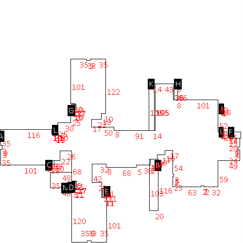 |
| Label |
Description |
Base SF |
Total SF |
| A |
SCHOOL-HIGH |
79749.00 |
79749.00 |
| B |
CANOPY W/ SLAB |
2294.00 |
.00 |
| C |
UTILITY STG-MAS |
200.00 |
.00 |
| D |
UTILITY STG-MAS |
198.00 |
.00 |
| E |
UTILITY STG-MAS |
231.00 |
.00 |
| F |
UTILITY STG-MAS |
350.00 |
.00 |
| G |
UTILITY STG-MAS |
180.00 |
.00 |
| H |
LOAD PLATFORM,CAN-GOOD |
288.00 |
.00 |
| I |
PORCH-OPEN-MAS |
40.00 |
.00 |
| J |
PORCH-OPEN-MAS |
40.00 |
.00 |
| K |
PORCH-OPEN-MAS |
1470.00 |
.00 |
| L |
UTILITY STG-MAS |
130.00 |
.00 |
| M |
PATIO-CONC |
1680.00 |
.00 |
|
|
|
|
|
| Map Acres |
33.59 |
| Tax District Note |
17 - C/SW/MOYTON FD |
| Present-Use Info |
PUBLIC SCHOOLS |
| Zoning Code |
AR |
| Zoning Desc |
AGRICUL-RESID 40M SF |
|
| Total Improvements Valuation
|
*Total Improvements Full Market Value $
|
**Total Improvements Assessed Value
|
8,265,557
|
8,265,557
|
*
Note - Market Value effective Date equal January 1, 2024, date of County’s most recent General
Reappraisal
** Note - If Assessed Value not equal Market Value then variance
resulting from formal appeal procedure |
|
| Land
Value Detail (Effective Date January 1, 2024, date
of County’s most recent General Reappraisal) |
Land
Full Value (LFV) $
|
Land
Present-Use Value (PUV) $ **
|
Land
Total Assessed Value $
|
397,074
|
397,074
|
397,074
|
| **
Note: If PUV equal LMV then parcel has
not qualified for present use program |
|
| Land
Detail (Effective Date January 1, 2024, date of County’s
most recent General Reappraisal) |
Rate Type |
Rate Code |
Description |
Quantity |
AC |
8300 |
SCHOOLS, PUBLIC |
22.000 |
|
|
|
.000 |
AC |
5111 |
MKT OPEN LD PVD CLASS 1 |
11.590 |
|
|
|
.000 |
|
|
|
|
