| LETCHWORTH WILLIAM ALFORD JR |
| LETCHWORTH FRANKIE PATE |
|
| PO BOX 9018 |
|
| WILSON , NC 27895-9018 |
|
| Property
Location Address |
| 8637 BUCKHORN PLANTATION RD |
|
| Parcel
ID No. |
2751541387.000 |
| PIN |
2751 54 1387 000 |
| Owner ID |
5668460 |
| |
|
| Tax
District |
19 - C/SW/ROCK RIDGE FD |
| |
| Land Use Code |
50 |
| Land Use Desc |
RURAL HOMESITE |
| |
|
| Neighborhood |
8050 - BUCKHORN_PLANTATION |
|
| Legal
Desc |
8637 BUCKHORN PLANTATION |
| |
L12 BUCKHORN PLAN 1.00LT |
| |
|
| Deed
Year Bk/Pg |
2001 - 1834 / 993 |
| Plat
Bk/Pg |
30 / 33 |
| |
Sales
Information |
| |
| Grantor |
|
| |
|
| Sold
Date |
0--0 |
| Sold
Amount $ |
0 |
|
| |
| Market Value $ |
519,063
|
| |
|
Market
Value - Land and all permanent improvements,
if any, effective January 1, 2024, date
of County’s most recent General Reappraisal
|
|
| |
|
| Assessed Value $ |
519,063
|
| |
If
Assessed Value not equal Market Value then
subject parcel designated as a special
class -agricultural, horticultural, or
forestland and thereby eligible for taxation
on basis of Present-Use.
|
|
|
| Year
Built |
2001 |
| Built
Use/Style |
SFR-UPTO 1.5 STY |
| Grade |
B / B GRADE |
| * Percent
Complete |
100 |
| Heated
Area (S/F) |
2,908 |
| Fireplace
(Y/N) |
Y |
| Basement
(Y/N) |
N |
| ** Bedroom(s) |
3 |
| ** Bathroom(s) |
3 Full Bath(s) 0 Half Bath(s) |
| *** Multiple
Improvements |
001 |
*
Note - As of January 1
*
* Note - Bathroom(s), Bedroom(s), shown for description
only
* * * Note - If multiple improvements equal “MLT” then
parcel includes additional major improvements |
|
| Photo |
Photo 1
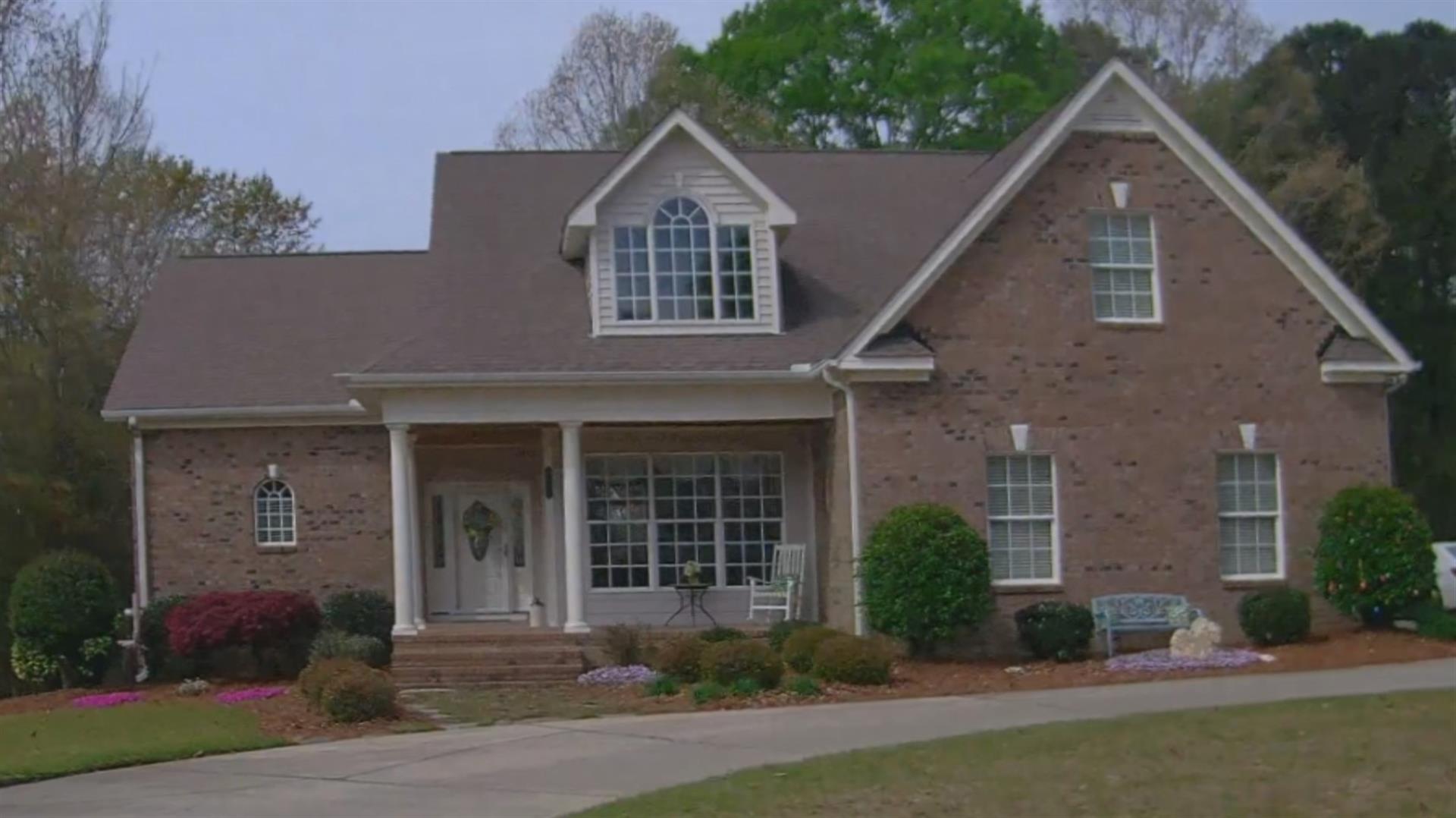
|
|
| Building
Sketch - NOTE: Sketches are updated the first day of every month. |
|
(Building 1) - Sketch for Parcel ID: 2751541387.000
NOTE: Sketches are updated the first day of every month.
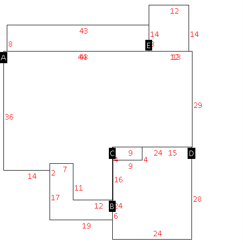 |
| Label |
Description |
Base SF |
Total SF |
| A |
SFR-1.5 STY |
1978.00 |
2552.00 |
| B |
PORCH-OPEN-MAS |
191.00 |
.00 |
| C |
UTILITY STG-FR |
36.00 |
.00 |
| D |
GARAGE-ATT-MAS |
636.00 |
.00 |
| E |
PORCH-SCR-MAS |
168.00 |
.00 |
| J |
PORCH-OPEN-MAS |
344.00 |
.00 |
|
|
|
|
|
| Map Acres |
0.918 |
| Tax District Note |
19 - C/SW/ROCK RIDGE FD |
| Present-Use Info |
RURAL HOMESITE |
| Zoning Code |
AR |
| Zoning Desc |
AGRICUL-RESID 40M SF |
|
| Total Improvements Valuation
|
*Total Improvements Full Market Value $
|
**Total Improvements Assessed Value
|
424,063
|
424,063
|
*
Note - Market Value effective Date equal January 1, 2024, date of County’s most recent General
Reappraisal
** Note - If Assessed Value not equal Market Value then variance
resulting from formal appeal procedure |
|
| Land
Value Detail (Effective Date January 1, 2024, date
of County’s most recent General Reappraisal) |
Land
Full Value (LFV) $
|
Land
Present-Use Value (PUV) $ **
|
Land
Total Assessed Value $
|
95,000
|
95,000
|
95,000
|
| **
Note: If PUV equal LMV then parcel has
not qualified for present use program |
|
| Land
Detail (Effective Date January 1, 2024, date of County’s
most recent General Reappraisal) |
Rate Type |
Rate Code |
Description |
Quantity |
LT |
0124 |
SFR WATER ACCESS |
1.000 |
|
|
|
.000 |
|
|
|
|
