| HINNANT DAVID JENNINGS |
| HINNANT VICKIE |
|
| 5704 NC HWY 581 N |
|
| KENLY , NC 27542-9038 |
|
| Property
Location Address |
|
| Parcel
ID No. |
2760347512.000 |
| PIN |
2760 34 7512 000 |
| Owner ID |
44606300 |
| |
|
| Tax
District |
19 - C/SW/ROCK RIDGE FD |
| |
| Land Use Code |
49 |
| Land Use Desc |
PREFAB WAREHOUSE |
| |
|
| Neighborhood |
8287 - SPRING_HILL |
|
| Legal
Desc |
5678 NC 581 HWY |
| |
55.20AC |
| |
|
| Deed
Year Bk/Pg |
2011 - 2437 / 58 |
| Plat
Bk/Pg |
/ |
| |
Sales
Information |
| |
| Grantor |
|
| |
|
| Sold
Date |
0--0 |
| Sold
Amount $ |
0 |
|
| |
| Market Value $ |
229,698
|
| |
|
Market
Value - Land and all permanent improvements,
if any, effective January 1, 2024, date
of County’s most recent General Reappraisal
|
|
| |
|
| Assessed Value $ |
149,215
|
| |
If
Assessed Value not equal Market Value then
subject parcel designated as a special
class -agricultural, horticultural, or
forestland and thereby eligible for taxation
on basis of Present-Use.
|
|
|
| Year
Built |
1991 |
| Built
Use/Style |
WAREHOUSE- PREFAB |
| Grade |
D-05 / D-05 GRADE |
| * Percent
Complete |
100 |
| Heated
Area (S/F) |
6,250 |
| Fireplace
(Y/N) |
N |
| Basement
(Y/N) |
N |
| ** Bedroom(s) |
0 |
| ** Bathroom(s) |
0 Full Bath(s) 0 Half Bath(s) |
| *** Multiple
Improvements |
001 |
*
Note - As of January 1
*
* Note - Bathroom(s), Bedroom(s), shown for description
only
* * * Note - If multiple improvements equal “MLT” then
parcel includes additional major improvements |
|
| Photo |
Photo 1
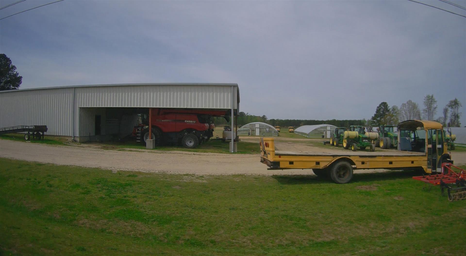
|
|
| Building
Sketch - NOTE: Sketches are updated the first day of every month. |
|
(Building 1) - Sketch for Parcel ID: 2760347512.000
NOTE: Sketches are updated the first day of every month.
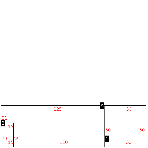 |
| Label |
Description |
Base SF |
Total SF |
| A |
WHSE-PREFAB |
5815.00 |
5815.00 |
| B |
OFFICE BUILDING |
435.00 |
435.00 |
| C |
CANOPY-AVERAGE |
2500.00 |
.00 |
|
|
|
|
|
| Map Acres |
55.2 |
| Tax District Note |
19 - C/SW/ROCK RIDGE FD |
| Present-Use Info |
PREFAB WAREHOUSE |
| Zoning Code |
AR |
| Zoning Desc |
AGRICUL-RESID 40M SF |
|
| Total Improvements Valuation
|
*Total Improvements Full Market Value $
|
**Total Improvements Assessed Value
|
92,669
|
92,669
|
*
Note - Market Value effective Date equal January 1, 2024, date of County’s most recent General
Reappraisal
** Note - If Assessed Value not equal Market Value then variance
resulting from formal appeal procedure |
|
| Land
Value Detail (Effective Date January 1, 2024, date
of County’s most recent General Reappraisal) |
Land
Full Value (LFV) $
|
Land
Present-Use Value (PUV) $ **
|
Land
Total Assessed Value $
|
137,029
|
56,546
|
56,546
|
| **
Note: If PUV equal LMV then parcel has
not qualified for present use program |
|
| Land
Detail (Effective Date January 1, 2024, date of County’s
most recent General Reappraisal) |
Rate Type |
Rate Code |
Description |
Quantity |
AC |
0600 |
INDUSTRIAL |
1.000 |
|
|
|
.000 |
AC |
5111 |
MKT OPEN LD PVD CLASS 1 |
17.230 |
LU |
5120 |
|
17.230 |
AC |
5211 |
MKT OPEN LD PVD CLASS 2 |
4.050 |
LU |
5220 |
|
4.050 |
AC |
5411 |
MKT OPEN LD PVD CLASS 4 |
10.000 |
LU |
5420 |
|
10.000 |
AC |
6111 |
MKT WOODS PVD CLASS 1 |
5.550 |
LU |
6120 |
|
5.550 |
AC |
6211 |
MKT WOODS PVD CLASS 2 |
17.370 |
LU |
6220 |
|
17.370 |
|
|
|
|
