| ROUNTREE ROBERT C M |
| ROUNTREE DELANA PARKER |
|
| 4517 RIVERBIRCH RD |
|
| WILSON , NC 27896 |
|
| Property
Location Address |
|
| Parcel
ID No. |
3724021735.000 |
| PIN |
3724 02 1735 000 |
| Owner ID |
1126546 |
| |
|
| Tax
District |
14 - C/SW/SILVER LAKE FD |
| |
| Land Use Code |
01 |
| Land Use Desc |
SINGLE FAMILY RESIDENTIAL |
| |
|
| Neighborhood |
8252 - RIVERBIRCH |
|
| Legal
Desc |
4517 RIVERBIRCH RD N |
| |
L41S1 RIVERBIRCH EST 1LT |
| |
|
| Deed
Year Bk/Pg |
2022 - 2956 / 834 |
| Plat
Bk/Pg |
21 / 135 |
| |
Sales
Information |
| |
| Grantor |
BARNETTE MELVIN RAY |
| |
BARNETTE RHONDA PEARCE |
| Sold
Date |
2022-04-04 |
| Sold
Amount $ |
575,000 |
|
| |
| Market Value $ |
612,541
|
| |
|
Market
Value - Land and all permanent improvements,
if any, effective January 1, 2024, date
of County’s most recent General Reappraisal
|
|
| |
|
| Assessed Value $ |
612,541
|
| |
If
Assessed Value not equal Market Value then
subject parcel designated as a special
class -agricultural, horticultural, or
forestland and thereby eligible for taxation
on basis of Present-Use.
|
|
|
| Year
Built |
1991 |
| Built
Use/Style |
SFR-UPTO 1.5 STY |
| Grade |
B-10 / B-10 GRADE |
| * Percent
Complete |
100 |
| Heated
Area (S/F) |
3,530 |
| Fireplace
(Y/N) |
N |
| Basement
(Y/N) |
N |
| ** Bedroom(s) |
3 |
| ** Bathroom(s) |
3 Full Bath(s) 1 Half Bath(s) |
| *** Multiple
Improvements |
002 |
*
Note - As of January 1
*
* Note - Bathroom(s), Bedroom(s), shown for description
only
* * * Note - If multiple improvements equal “MLT” then
parcel includes additional major improvements |
|
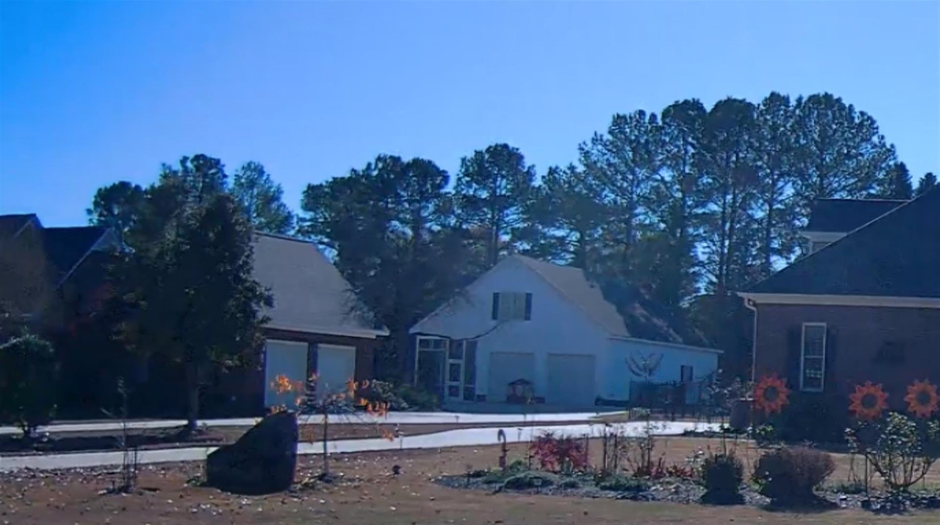
| Photo |
Photo 1
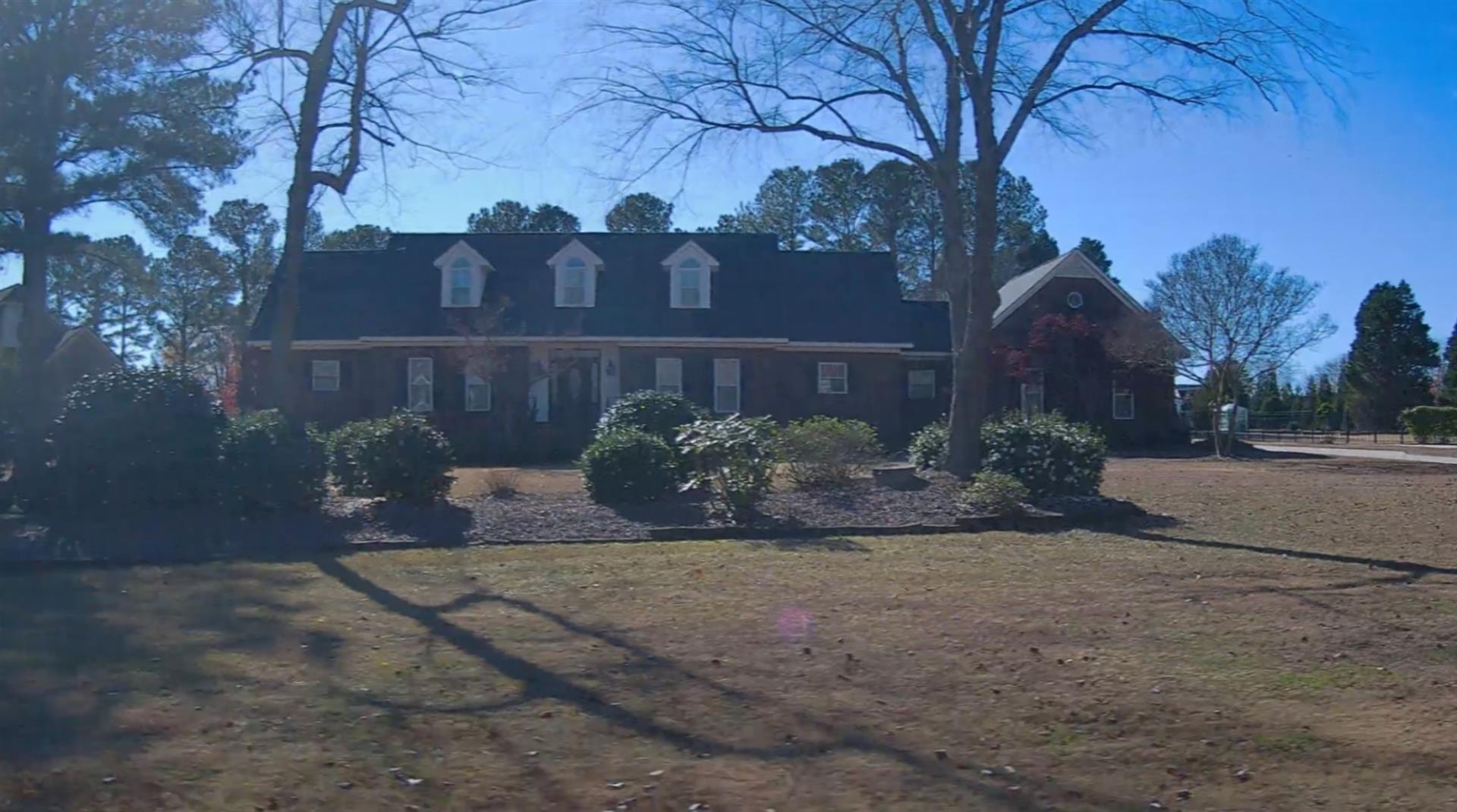 Photo 2
|
|
| Building
Sketch - NOTE: Sketches are updated the first day of every month. |
|
(Building 1) - Sketch for Parcel ID: 3724021735.000
NOTE: Sketches are updated the first day of every month.
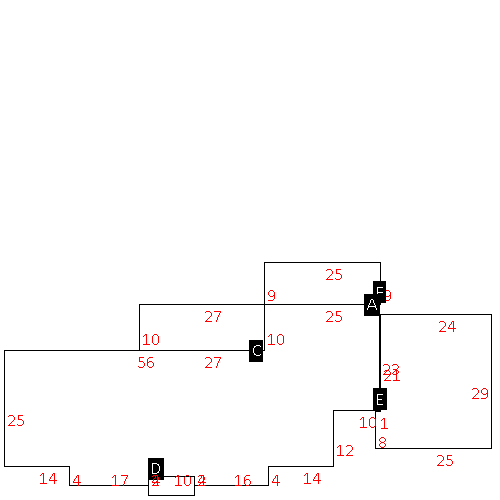 |
| Label |
Description |
Base SF |
Total SF |
| A |
SFR-1.5 STY |
2307.00 |
3322.00 |
| C |
PORCH-SCR-MAS |
270.00 |
.00 |
| D |
PORCH-OPEN-MAS |
40.00 |
.00 |
| E |
GARAGE-ATT-MAS |
704.00 |
.00 |
| F |
PATIO-CONC |
225.00 |
.00 |
|
|
(Building 2) - Sketch for Parcel ID: 3724021735.000
NOTE: Sketches are updated the first day of every month.
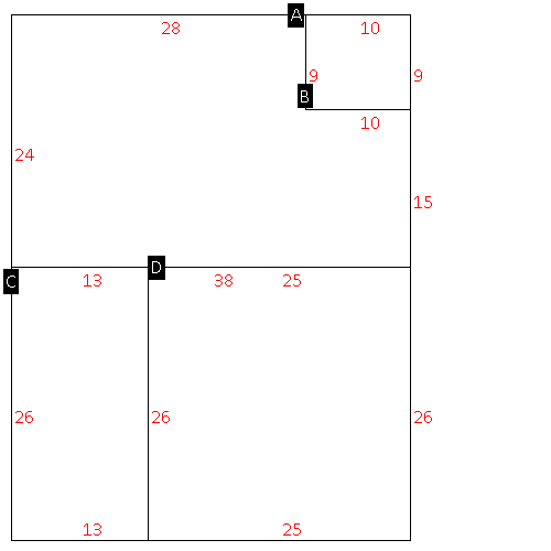 |
| Label |
Description |
Base SF |
Total SF |
| A |
SFR-1.5 STY |
822.00 |
1570.00 |
| B |
UTILITY STG-FR |
90.00 |
.00 |
| C |
PORCH-SCR-MAS |
338.00 |
.00 |
| D |
GARAGE-ATT-FR |
650.00 |
.00 |
|
|
|
|
|
| Map Acres |
1.038 |
| Tax District Note |
14 - C/SW/SILVER LAKE FD |
| Present-Use Info |
SINGLE FAMILY RESIDENTIAL |
| Zoning Code |
RA |
| Zoning Desc |
RESIDENTAL AGRICULTURAL |
|
| Total Improvements Valuation
|
*Total Improvements Full Market Value $
|
**Total Improvements Assessed Value
|
557,541
|
557,541
|
*
Note - Market Value effective Date equal January 1, 2024, date of County’s most recent General
Reappraisal
** Note - If Assessed Value not equal Market Value then variance
resulting from formal appeal procedure |
|
| Land
Value Detail (Effective Date January 1, 2024, date
of County’s most recent General Reappraisal) |
Land
Full Value (LFV) $
|
Land
Present-Use Value (PUV) $ **
|
Land
Total Assessed Value $
|
55,000
|
55,000
|
55,000
|
| **
Note: If PUV equal LMV then parcel has
not qualified for present use program |
|
| Land
Detail (Effective Date January 1, 2024, date of County’s
most recent General Reappraisal) |
Rate Type |
Rate Code |
Description |
Quantity |
LT |
0100 |
SINGLE FAMILY RESIDENTIAL |
1.000 |
|
|
|
.000 |
|
|
|
|
