| JOHNSON WILLIAM D & E A (LER) |
| HENDERSON PAULA& THORNE LEIGH |
|
| 4547 NC HWY 581 |
|
| SIMS , NC 27880-9441 |
|
| Property
Location Address |
|
| Parcel
ID No. |
2762346406.000 |
| PIN |
2762 34 6406 000 |
| Owner ID |
1125991 |
| |
|
| Tax
District |
21 - C/SW/GREEN HORNET FD |
| |
| Land Use Code |
50 |
| Land Use Desc |
RURAL HOMESITE |
| |
|
| Neighborhood |
8219 - OLD_FIELDS |
|
| Legal
Desc |
4443 NC 581 HWY |
| |
BULLOCK LD 31.67AC |
| |
|
| Deed
Year Bk/Pg |
2022 - 2948 / 551 |
| Plat
Bk/Pg |
/ |
| |
Sales
Information |
| |
| Grantor |
JOHNSON WILLIAM D& ELIZABETH A |
| |
HENDERSON PAULA& THORNE LEIGH |
| Sold
Date |
2022-02-14 |
| Sold
Amount $ |
13,000 |
|
| |
| Market Value $ |
151,496
|
| |
|
Market
Value - Land and all permanent improvements,
if any, effective January 1, 2024, date
of County’s most recent General Reappraisal
|
|
| |
|
| Assessed Value $ |
102,045
|
| |
If
Assessed Value not equal Market Value then
subject parcel designated as a special
class -agricultural, horticultural, or
forestland and thereby eligible for taxation
on basis of Present-Use.
|
|
|
| Year
Built |
1925 |
| Built
Use/Style |
SFR-1.0 STY |
| Grade |
C-10 / C-10 GRADE |
| * Percent
Complete |
100 |
| Heated
Area (S/F) |
1,142 |
| Fireplace
(Y/N) |
N |
| Basement
(Y/N) |
N |
| ** Bedroom(s) |
3 |
| ** Bathroom(s) |
1 Full Bath(s) 0 Half Bath(s) |
| *** Multiple
Improvements |
001 |
*
Note - As of January 1
*
* Note - Bathroom(s), Bedroom(s), shown for description
only
* * * Note - If multiple improvements equal “MLT” then
parcel includes additional major improvements |
|
| Photo |
Photo 1

|
|
| Building
Sketch - NOTE: Sketches are updated the first day of every month. |
|
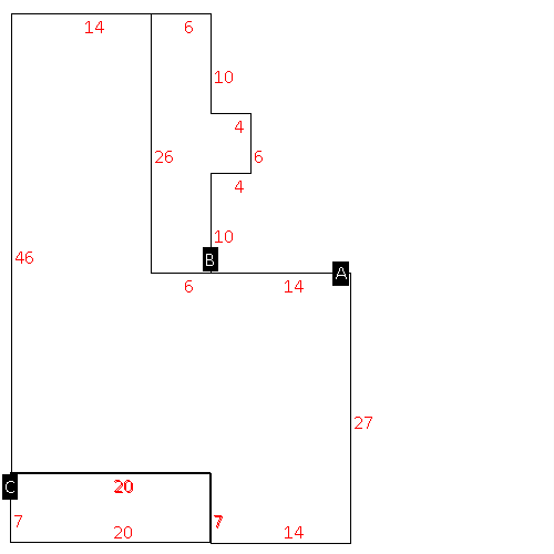
(Building 1) - Sketch for Parcel ID: 2762346406.000
NOTE: Sketches are updated the first day of every month.
 |
| Label |
Description |
Base SF |
Total SF |
| A |
SFR-1.0 STY |
1142.00 |
1142.00 |
| B |
PORCH-SCR-MAS |
180.00 |
.00 |
| C |
PORCH-OPEN-FR |
140.00 |
.00 |
|
|
|
|
|
| Map Acres |
31.67 |
| Tax District Note |
21 - C/SW/GREEN HORNET FD |
| Present-Use Info |
RURAL HOMESITE |
| Zoning Code |
AR |
| Zoning Desc |
AGRICUL-RESID 40M SF |
|
| Total Improvements Valuation
|
*Total Improvements Full Market Value $
|
**Total Improvements Assessed Value
|
47,753
|
47,753
|
*
Note - Market Value effective Date equal January 1, 2024, date of County’s most recent General
Reappraisal
** Note - If Assessed Value not equal Market Value then variance
resulting from formal appeal procedure |
|
| Land
Value Detail (Effective Date January 1, 2024, date
of County’s most recent General Reappraisal) |
Land
Full Value (LFV) $
|
Land
Present-Use Value (PUV) $ **
|
Land
Total Assessed Value $
|
103,743
|
54,292
|
54,292
|
| **
Note: If PUV equal LMV then parcel has
not qualified for present use program |
|
| Land
Detail (Effective Date January 1, 2024, date of County’s
most recent General Reappraisal) |
Rate Type |
Rate Code |
Description |
Quantity |
AC |
5010 |
RURAL HOMESITE PAVED |
1.000 |
|
|
|
.000 |
AC |
5211 |
MKT OPEN LD PVD CLASS 2 |
15.690 |
LU |
5220 |
|
15.690 |
AC |
6111 |
MKT WOODS PVD CLASS 1 |
1.610 |
LU |
6120 |
|
1.610 |
AC |
6211 |
MKT WOODS PVD CLASS 2 |
1.430 |
LU |
6220 |
|
1.430 |
AC |
6311 |
MKT WOODS PVD CLASS 3 |
11.940 |
LU |
6320 |
|
11.940 |
|
|
|
|
