| ROBERTSON JEREMY DANIEL |
| ROBERTSON JANAE MELISSA |
|
| PO BOX 203 |
|
| BLACK CREEK , NC 27813 |
|
| Property
Location Address |
|
| Parcel
ID No. |
3618528731.000 |
| PIN |
3618 52 8731 000 |
| Owner ID |
1117619 |
| |
|
| Tax
District |
16 - C/SW/LEE WOODARD FD |
| |
| Land Use Code |
02 |
| Land Use Desc |
MANUFACTURED HOME (DW) |
| |
|
| Neighborhood |
8030 - BLACK_CREEK_RA |
|
| Legal
Desc |
405 DEER TRAIL LN |
| |
19.38AC |
| |
|
| Deed
Year Bk/Pg |
2019 - 2806 / 488 |
| Plat
Bk/Pg |
/ |
| |
Sales
Information |
| |
| Grantor |
ANGEL NICOLE RADFORD TRUST |
| |
|
| Sold
Date |
2019-10-21 |
| Sold
Amount $ |
157,000 |
|
| |
| Market Value $ |
201,828
|
| |
|
Market
Value - Land and all permanent improvements,
if any, effective January 1, 2024, date
of County’s most recent General Reappraisal
|
|
| |
|
| Assessed Value $ |
201,828
|
| |
If
Assessed Value not equal Market Value then
subject parcel designated as a special
class -agricultural, horticultural, or
forestland and thereby eligible for taxation
on basis of Present-Use.
|
|
|
| Year
Built |
2016 |
| Built
Use/Style |
MH-DOUBLE WIDE |
| Grade |
C / C GRADE |
| * Percent
Complete |
100 |
| Heated
Area (S/F) |
1,836 |
| Fireplace
(Y/N) |
N |
| Basement
(Y/N) |
N |
| ** Bedroom(s) |
3 |
| ** Bathroom(s) |
2 Full Bath(s) 0 Half Bath(s) |
| *** Multiple
Improvements |
001 |
*
Note - As of January 1
*
* Note - Bathroom(s), Bedroom(s), shown for description
only
* * * Note - If multiple improvements equal “MLT” then
parcel includes additional major improvements |
|
| Photo |
Photo 1

|
|
| Building
Sketch - NOTE: Sketches are updated the first day of every month. |
|
(Building 1) - Sketch for Parcel ID: 3618528731.000
NOTE: Sketches are updated the first day of every month.
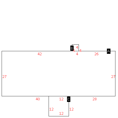 |
| Label |
Description |
Base SF |
Total SF |
| A |
MFG-DOUBLE WIDE |
1836.00 |
1836.00 |
| B |
DECK-WOOD |
16.00 |
.00 |
| C |
PORCH-SCR-MAS |
144.00 |
.00 |
|
|
|
|
|
| Map Acres |
19.38 |
| Tax District Note |
16 - C/SW/LEE WOODARD FD |
| Present-Use Info |
MANUFACTURED HOME (DW) |
| Zoning Code |
RA |
| Zoning Desc |
RESIDENTAL AGRICULTURAL |
|
| Total Improvements Valuation
|
*Total Improvements Full Market Value $
|
**Total Improvements Assessed Value
|
175,862
|
175,862
|
*
Note - Market Value effective Date equal January 1, 2024, date of County’s most recent General
Reappraisal
** Note - If Assessed Value not equal Market Value then variance
resulting from formal appeal procedure |
|
| Land
Value Detail (Effective Date January 1, 2024, date
of County’s most recent General Reappraisal) |
Land
Full Value (LFV) $
|
Land
Present-Use Value (PUV) $ **
|
Land
Total Assessed Value $
|
25,966
|
25,966
|
25,966
|
| **
Note: If PUV equal LMV then parcel has
not qualified for present use program |
|
| Land
Detail (Effective Date January 1, 2024, date of County’s
most recent General Reappraisal) |
Rate Type |
Rate Code |
Description |
Quantity |
AC |
5030 |
RURAL HOMESITE REAR NO RD |
1.000 |
|
|
|
.000 |
AC |
5113 |
MKT OPEN LD REAR CLASS 1 |
2.000 |
|
|
|
.000 |
AC |
6113 |
MKT WOODS REAR CLASS 1 |
16.380 |
|
|
|
.000 |
|
|
|
|
