| STARLING PERCY GERALD |
| STARLING SANDRA S |
|
| 701 E SECOND ST |
|
| KENLY , NC 27542-8362 |
|
| Property
Location Address |
|
| Parcel
ID No. |
2667167928.000 |
| PIN |
2667 16 7928 000 |
| Owner ID |
1108089 |
| |
|
| Tax
District |
20 - C/SW/BEULAH FD |
| |
| Land Use Code |
50 |
| Land Use Desc |
RURAL HOMESITE |
| |
|
| Neighborhood |
8287 - SPRING_HILL |
|
| Legal
Desc |
9320 ST MARYS CHURCH RD |
| |
56.58AC |
| |
|
| Deed
Year Bk/Pg |
2016 - 2665 / 12 |
| Plat
Bk/Pg |
/ |
| |
Sales
Information |
| |
| Grantor |
STARLING PERCY L (HEIRS) |
| |
|
| Sold
Date |
2016-08-03 |
| Sold
Amount $ |
498,000 |
|
| |
| Market Value $ |
206,804
|
| |
|
Market
Value - Land and all permanent improvements,
if any, effective January 1, 2024, date
of County’s most recent General Reappraisal
|
|
| |
|
| Assessed Value $ |
146,967
|
| |
If
Assessed Value not equal Market Value then
subject parcel designated as a special
class -agricultural, horticultural, or
forestland and thereby eligible for taxation
on basis of Present-Use.
|
|
|
| Year
Built |
1910 |
| Built
Use/Style |
SFR-1.0 STY |
| Grade |
D / D GRADE |
| * Percent
Complete |
100 |
| Heated
Area (S/F) |
1,318 |
| Fireplace
(Y/N) |
N |
| Basement
(Y/N) |
N |
| ** Bedroom(s) |
3 |
| ** Bathroom(s) |
1 Full Bath(s) 0 Half Bath(s) |
| *** Multiple
Improvements |
001 |
*
Note - As of January 1
*
* Note - Bathroom(s), Bedroom(s), shown for description
only
* * * Note - If multiple improvements equal “MLT” then
parcel includes additional major improvements |
|
| Photo |
Photo 1

|
|
| Building
Sketch - NOTE: Sketches are updated the first day of every month. |
|
(Building 1) - Sketch for Parcel ID: 2667167928.000
NOTE: Sketches are updated the first day of every month.
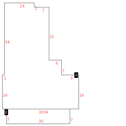 |
| Label |
Description |
Base SF |
Total SF |
| A |
SFR-1.0 STY |
1318.00 |
1318.00 |
| B |
PORCH-OPEN-FR |
210.00 |
.00 |
|
|
|
|
|
| Map Acres |
56.58 |
| Tax District Note |
20 - C/SW/BEULAH FD |
| Present-Use Info |
RURAL HOMESITE |
| Zoning Code |
RA20 |
| Zoning Desc |
RESIDENTIAL 20000 SF LUC |
|
| Total Improvements Valuation
|
*Total Improvements Full Market Value $
|
**Total Improvements Assessed Value
|
52,369
|
52,369
|
*
Note - Market Value effective Date equal January 1, 2024, date of County’s most recent General
Reappraisal
** Note - If Assessed Value not equal Market Value then variance
resulting from formal appeal procedure |
|
| Land
Value Detail (Effective Date January 1, 2024, date
of County’s most recent General Reappraisal) |
Land
Full Value (LFV) $
|
Land
Present-Use Value (PUV) $ **
|
Land
Total Assessed Value $
|
154,435
|
94,598
|
94,598
|
| **
Note: If PUV equal LMV then parcel has
not qualified for present use program |
|
| Land
Detail (Effective Date January 1, 2024, date of County’s
most recent General Reappraisal) |
Rate Type |
Rate Code |
Description |
Quantity |
AC |
5010 |
RURAL HOMESITE PAVED |
1.000 |
|
|
|
.000 |
AC |
9952 |
CELL TOWER |
1.000 |
|
|
|
.000 |
AC |
5111 |
MKT OPEN LD PVD CLASS 1 |
29.250 |
LU |
5110 |
|
29.250 |
AC |
6111 |
MKT WOODS PVD CLASS 1 |
25.330 |
LU |
6110 |
|
25.330 |
|
|
|
|
