|
|
| 2156 JOELENE DR |
|
| ROCKY MOUNT , NC 27803 |
|
| Property
Location Address |
|
| Parcel
ID No. |
3702699951.000 |
| PIN |
3702 69 9951 000 |
| Previous Parcel |
3702791762.000 |
| Owner ID |
1104917 |
| |
|
| Tax
District |
31 - C/CIWI-WILSON |
| |
| Land Use Code |
60 |
| Land Use Desc |
GARDEN APARTMENT |
| |
|
| Neighborhood |
8006 - AIRPORT_BLVD_O-2 |
|
| Legal
Desc |
3710 ASHBROOK DR NW |
| |
L37 3.23AC |
| |
|
| Deed
Year Bk/Pg |
2023 - 3006 / 409 |
| Plat
Bk/Pg |
41 / 241 |
| |
Sales
Information |
| |
| Grantor |
JP & RM LLC |
| |
|
| Sold
Date |
2023-03-02 |
| Sold
Amount $ |
2,500,000 |
|
| |
| Market Value $ |
1,898,109
|
| |
|
Market
Value - Land and all permanent improvements,
if any, effective January 1, 2024, date
of County’s most recent General Reappraisal
|
|
| |
|
| Assessed Value $ |
1,898,109
|
| |
If
Assessed Value not equal Market Value then
subject parcel designated as a special
class -agricultural, horticultural, or
forestland and thereby eligible for taxation
on basis of Present-Use.
|
|
|
| Year
Built |
2020 |
| Built
Use/Style |
APARTMENT-DUPLEX/TRIPLEX |
| Grade |
C+05 / C+05 GRADE |
| * Percent
Complete |
100 |
| Heated
Area (S/F) |
2,150 |
| Fireplace
(Y/N) |
N |
| Basement
(Y/N) |
N |
| ** Bedroom(s) |
0 |
| ** Bathroom(s) |
0 Full Bath(s) 0 Half Bath(s) |
| *** Multiple
Improvements |
006 |
*
Note - As of January 1
*
* Note - Bathroom(s), Bedroom(s), shown for description
only
* * * Note - If multiple improvements equal “MLT” then
parcel includes additional major improvements |
|
| Photo |
Photo 1
 Photo 1
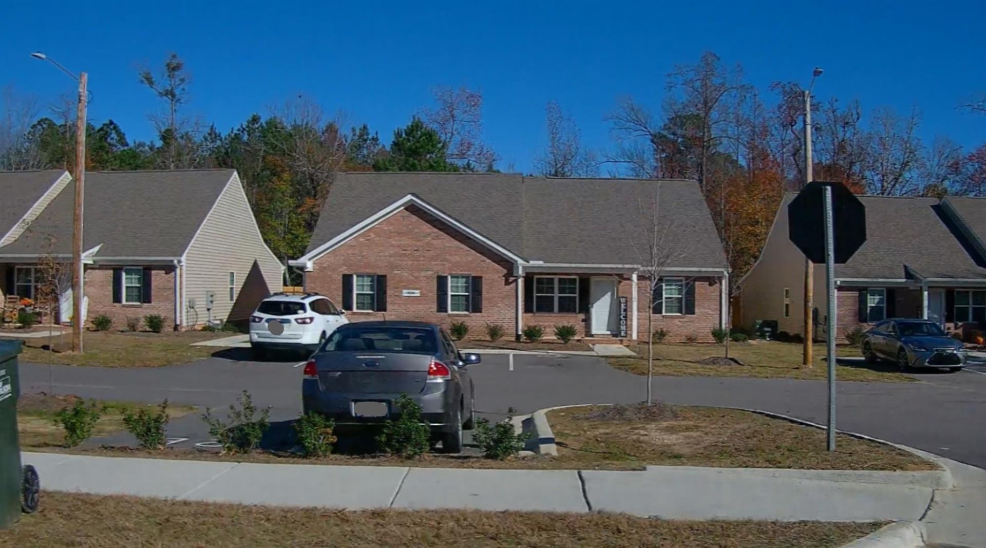 Photo 1
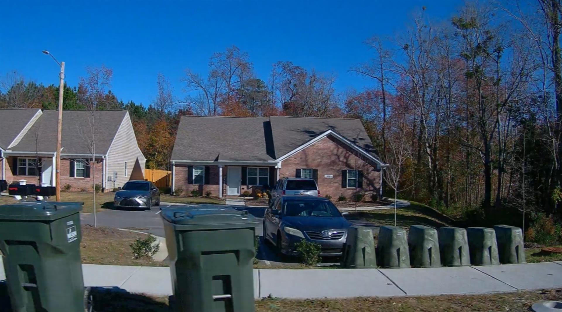 Photo 1
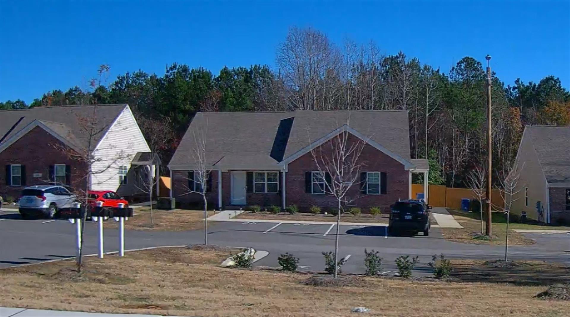 Photo 1
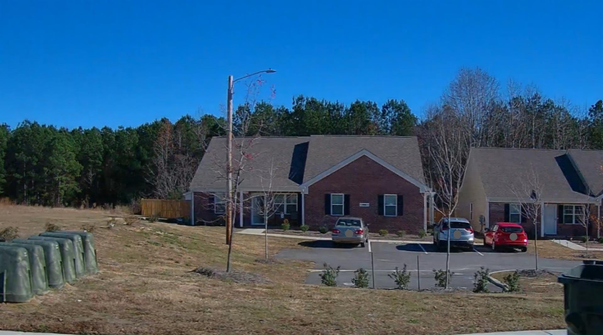
|
|
| Building
Sketch - NOTE: Sketches are updated the first day of every month. |
|
(Building 1) - Sketch for Parcel ID: 3702699951.000
NOTE: Sketches are updated the first day of every month.
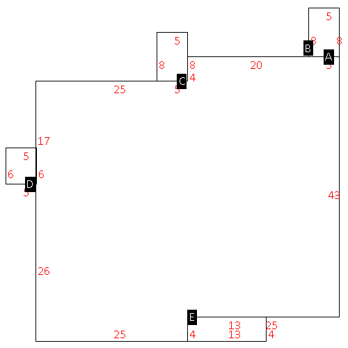 |
| Label |
Description |
Base SF |
Total SF |
| A |
APT-DUPLEX/TRIPLEX |
2150.00 |
2150.00 |
| B |
UTILITY STG-FR |
40.00 |
.00 |
| C |
UTILITY STG-FR |
40.00 |
.00 |
| D |
PORCH-OPEN-MAS |
30.00 |
.00 |
| E |
PORCH-OPEN-MAS |
52.00 |
.00 |
|
|
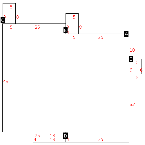
(Building 2) - Sketch for Parcel ID: 3702699951.000
NOTE: Sketches are updated the first day of every month.
 |
| Label |
Description |
Base SF |
Total SF |
| A |
APT-DUPLEX/TRIPLEX |
2150.00 |
2150.00 |
| B |
UTILITY STG-FR |
40.00 |
.00 |
| C |
UTILITY STG-FR |
40.00 |
.00 |
| D |
PORCH-OPEN-MAS |
30.00 |
.00 |
| E |
PORCH-OPEN-MAS |
52.00 |
.00 |
|
|
(Building 3) - Sketch for Parcel ID: 3702699951.000
NOTE: Sketches are updated the first day of every month.
 |
| Label |
Description |
Base SF |
Total SF |
| A |
APT-DUPLEX/TRIPLEX |
2150.00 |
2150.00 |
| B |
PORCH-OPEN-MAS |
40.00 |
.00 |
| C |
PORCH-OPEN-MAS |
40.00 |
.00 |
| D |
UTILITY STG-FR |
52.00 |
.00 |
| E |
UTILITY STG-FR |
30.00 |
.00 |
|
|
(Building 4) - Sketch for Parcel ID: 3702699951.000
NOTE: Sketches are updated the first day of every month.
 |
| Label |
Description |
Base SF |
Total SF |
| A |
APT-DUPLEX/TRIPLEX |
2150.00 |
2150.00 |
| B |
UTILITY STG-FR |
40.00 |
.00 |
| C |
UTILITY STG-FR |
40.00 |
.00 |
| D |
PORCH-OPEN-MAS |
52.00 |
.00 |
| E |
PORCH-OPEN-MAS |
30.00 |
.00 |
|
|
(Building 5) - Sketch for Parcel ID: 3702699951.000
NOTE: Sketches are updated the first day of every month.
 |
| Label |
Description |
Base SF |
Total SF |
| A |
APT-DUPLEX/TRIPLEX |
2150.00 |
2150.00 |
| B |
UTILITY STG-FR |
40.00 |
.00 |
| C |
UTILITY STG-FR |
40.00 |
.00 |
| D |
PORCH-OPEN-MAS |
52.00 |
.00 |
| E |
PORCH-OPEN-MAS |
30.00 |
.00 |
|
|
(Building 6) - Sketch for Parcel ID: 3702699951.000
NOTE: Sketches are updated the first day of every month.
 |
| Label |
Description |
Base SF |
Total SF |
| A |
APT-DUPLEX/TRIPLEX |
2150.00 |
2150.00 |
| B |
PORCH-OPEN-MAS |
40.00 |
.00 |
| C |
PORCH-OPEN-MAS |
40.00 |
.00 |
| D |
UTILITY STG-FR |
52.00 |
.00 |
| E |
UTILITY STG-FR |
30.00 |
.00 |
|
|
|
|
|
| Map Acres |
3.23 |
| Tax District Note |
31 - C/CIWI-WILSON |
| Present-Use Info |
GARDEN APARTMENT |
| Zoning Code |
RMX |
| Zoning Desc |
RESIDENTIAL MIXED USE |
|
| Total Improvements Valuation
|
*Total Improvements Full Market Value $
|
**Total Improvements Assessed Value
|
1,758,198
|
1,758,198
|
*
Note - Market Value effective Date equal January 1, 2024, date of County’s most recent General
Reappraisal
** Note - If Assessed Value not equal Market Value then variance
resulting from formal appeal procedure |
|
| Land
Value Detail (Effective Date January 1, 2024, date
of County’s most recent General Reappraisal) |
Land
Full Value (LFV) $
|
Land
Present-Use Value (PUV) $ **
|
Land
Total Assessed Value $
|
139,911
|
139,911
|
139,911
|
| **
Note: If PUV equal LMV then parcel has
not qualified for present use program |
|
| Land
Detail (Effective Date January 1, 2024, date of County’s
most recent General Reappraisal) |
Rate Type |
Rate Code |
Description |
Quantity |
AC |
0561 |
MULTI-FAMILY TOWNHOUSE |
2.790 |
|
|
|
.000 |
AC |
9600 |
WASTELAND |
.440 |
|
|
|
.000 |
|
|
|
|
