| SECURCARE PORTFOLIO HOLDINGS |
| LLC |
|
| 8400 E PRENTICE AVE STE 900 |
|
| GREENWOOD VILLAGE , CO 80111 |
|
| Property
Location Address |
|
| Parcel
ID No. |
3712221857.000 |
| PIN |
3712 22 1857 000 |
| Owner ID |
1103865 |
| |
|
| Tax
District |
31 - C/CIWI-WILSON |
| |
| Land Use Code |
17 |
| Land Use Desc |
OFFICE |
| |
|
| Neighborhood |
8244 - RALEIGH_ROAD_PKWY_B-4 |
|
| Legal
Desc |
1900 WESTWOOD AVE W |
| |
3.07AC |
| |
|
| Deed
Year Bk/Pg |
2014 - 2598 / 9 |
| Plat
Bk/Pg |
29 / 116 |
| |
Sales
Information |
| |
| Grantor |
RHR & COMPANY INC |
| |
|
| Sold
Date |
2014-12-12 |
| Sold
Amount $ |
2,825,000 |
|
| |
| Market Value $ |
2,254,288
|
| |
|
Market
Value - Land and all permanent improvements,
if any, effective January 1, 2024, date
of County’s most recent General Reappraisal
|
|
| |
|
| Assessed Value $ |
2,254,288
|
| |
If
Assessed Value not equal Market Value then
subject parcel designated as a special
class -agricultural, horticultural, or
forestland and thereby eligible for taxation
on basis of Present-Use.
|
|
|
| Year
Built |
2005 |
| Built
Use/Style |
MINI-WAREHOUSES |
| Grade |
C+05 / C+05 GRADE |
| * Percent
Complete |
100 |
| Heated
Area (S/F) |
11,375 |
| Fireplace
(Y/N) |
N |
| Basement
(Y/N) |
N |
| ** Bedroom(s) |
0 |
| ** Bathroom(s) |
0 Full Bath(s) 0 Half Bath(s) |
| *** Multiple
Improvements |
008 |
*
Note - As of January 1
*
* Note - Bathroom(s), Bedroom(s), shown for description
only
* * * Note - If multiple improvements equal “MLT” then
parcel includes additional major improvements |
|
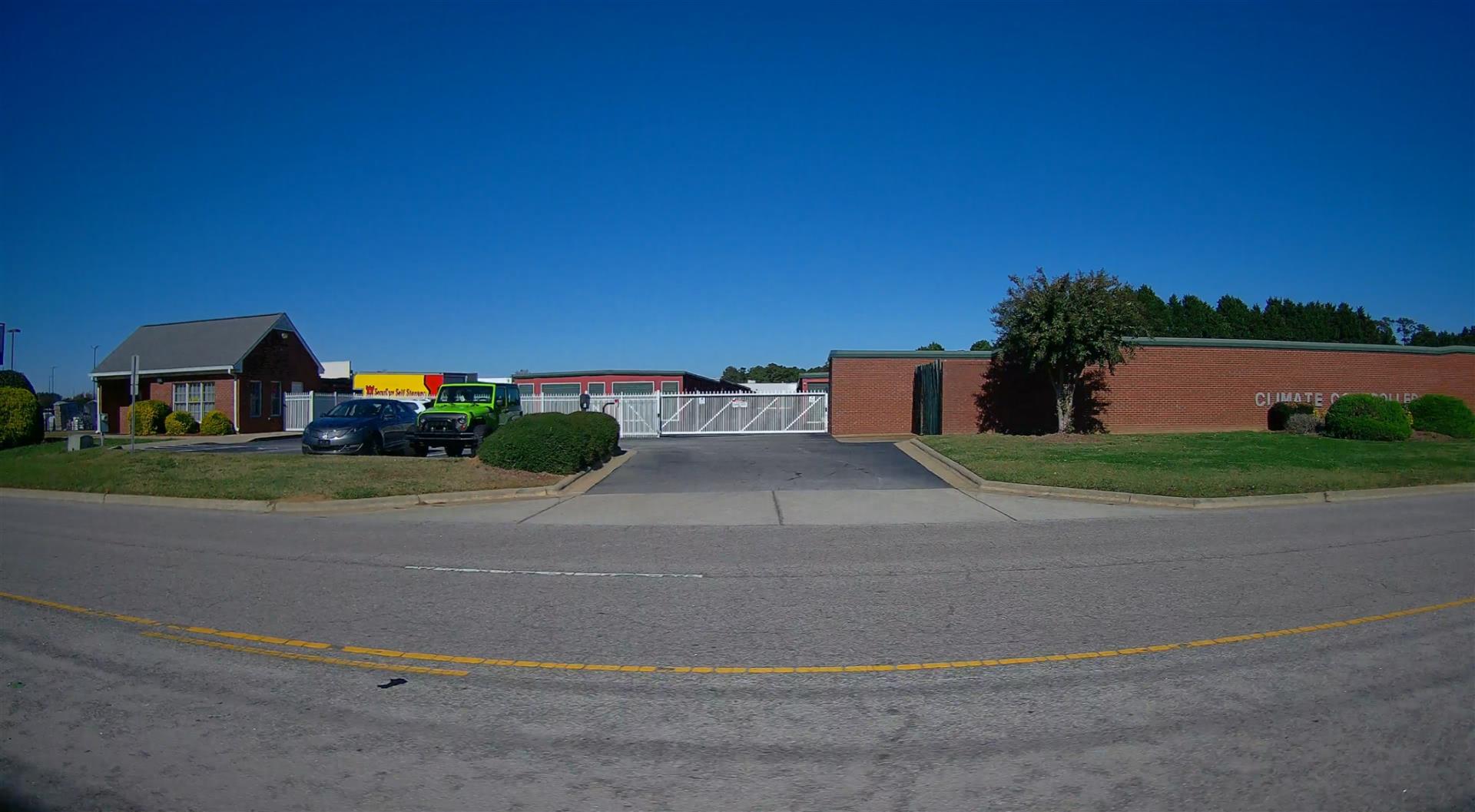
| Photo |
Photo 1
|
|
| Building
Sketch - NOTE: Sketches are updated the first day of every month. |
|
(Building 1) - Sketch for Parcel ID: 3712221857.000
NOTE: Sketches are updated the first day of every month.
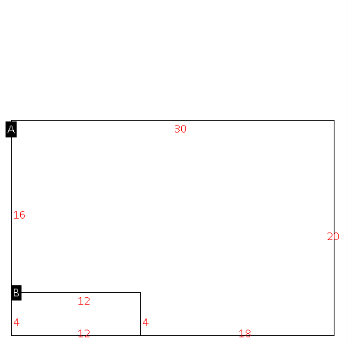 |
| Label |
Description |
Base SF |
Total SF |
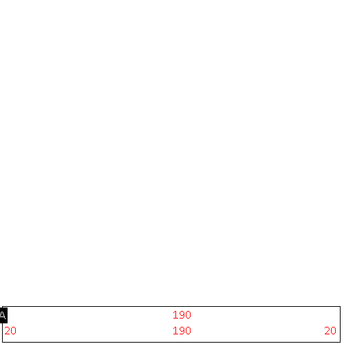
| A |
OFFICE BUILDING |
552.00 |
552.00 |
| B |
PORCH-OPEN-FR |
48.00 |
.00 |
|
|
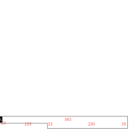
(Building 2) - Sketch for Parcel ID: 3712221857.000
NOTE: Sketches are updated the first day of every month.
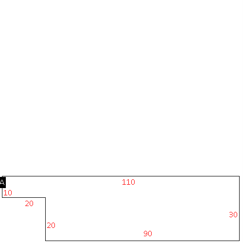 |
| Label |
Description |
Base SF |
Total SF |
| A |
MINI-WHSE |
2900.00 |
2900.00 |
|
|
(Building 3) - Sketch for Parcel ID: 3712221857.000
NOTE: Sketches are updated the first day of every month.
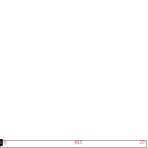 |
| Label |
Description |
Base SF |
Total SF |
| A |
MINI-WHSE |
8300.00 |
8300.00 |
|
|
(Building 4) - Sketch for Parcel ID: 3712221857.000
NOTE: Sketches are updated the first day of every month.
 |
| Label |
Description |
Base SF |
Total SF |
| A |
MINI-WHSE |
3800.00 |
3800.00 |
|
|
(Building 5) - Sketch for Parcel ID: 3712221857.000
NOTE: Sketches are updated the first day of every month.
 |
| Label |
Description |
Base SF |
Total SF |
| A |
MINI-WHSE |
2800.00 |
2800.00 |
|
|
(Building 6) - Sketch for Parcel ID: 3712221857.000
NOTE: Sketches are updated the first day of every month.
 |
| Label |
Description |
Base SF |
Total SF |
| A |
MINI-WHSE |
10750.00 |
10750.00 |
|
|
(Building 7) - Sketch for Parcel ID: 3712221857.000
NOTE: Sketches are updated the first day of every month.
 |
| Label |
Description |
Base SF |
Total SF |
| A |
MINI-WHSE |
10950.00 |
10950.00 |
|
|
(Building 8) - Sketch for Parcel ID: 3712221857.000
NOTE: Sketches are updated the first day of every month.
 |
| Label |
Description |
Base SF |
Total SF |
| A |
MINI-WHSE |
11375.00 |
11375.00 |
|
|
|
|
|
| Map Acres |
3.07 |
| Tax District Note |
31 - C/CIWI-WILSON |
| Present-Use Info |
OFFICE |
| Zoning Code |
HC |
| Zoning Desc |
HIGHWAY COMMERCIAL |
|
| Total Improvements Valuation
|
*Total Improvements Full Market Value $
|
**Total Improvements Assessed Value
|
1,652,508
|
1,652,508
|
*
Note - Market Value effective Date equal January 1, 2024, date of County’s most recent General
Reappraisal
** Note - If Assessed Value not equal Market Value then variance
resulting from formal appeal procedure |
|
| Land
Value Detail (Effective Date January 1, 2024, date
of County’s most recent General Reappraisal) |
Land
Full Value (LFV) $
|
Land
Present-Use Value (PUV) $ **
|
Land
Total Assessed Value $
|
601,780
|
601,780
|
601,780
|
| **
Note: If PUV equal LMV then parcel has
not qualified for present use program |
|
| Land
Detail (Effective Date January 1, 2024, date of County’s
most recent General Reappraisal) |
Rate Type |
Rate Code |
Description |
Quantity |
SF |
0628 |
MINI-WAREHOUSE |
133729.000 |
|
|
|
.000 |
|
|
|
|
