| SOUTHEASTERN GRAIN COMPANY LLC |
| |
|
| PO BOX 3649 |
|
| WILMINGTON , NC 27406 |
|
| Property
Location Address |
|
| Parcel
ID No. |
3721024925.000 |
| PIN |
3721 02 4925 000 |
| Owner ID |
1097918 |
| |
|
| Tax
District |
31 - C/CIWI-WILSON |
| |
| Land Use Code |
40 |
| Land Use Desc |
INDUSTRIAL |
| |
|
| Neighborhood |
8344 - US_301-WARD_I-1 |
|
| Legal
Desc |
1711 US 301 HWY S |
| |
12.73AC |
| |
|
| Deed
Year Bk/Pg |
2013 - 2526 / 942 |
| Plat
Bk/Pg |
44 / 173 |
| |
Sales
Information |
| |
| Grantor |
CORNERSTONE BANK |
| |
NASH STREET BRANCH |
| Sold
Date |
2013-04-12 |
| Sold
Amount $ |
800,000 |
|
| |
| Market Value $ |
1,289,050
|
| |
|
Market
Value - Land and all permanent improvements,
if any, effective January 1, 2024, date
of County’s most recent General Reappraisal
|
|
| |
|
| Assessed Value $ |
1,289,050
|
| |
If
Assessed Value not equal Market Value then
subject parcel designated as a special
class -agricultural, horticultural, or
forestland and thereby eligible for taxation
on basis of Present-Use.
|
|
|
| Year
Built |
1954 |
| Built
Use/Style |
INDUSTRIAL |
| Grade |
C / C GRADE |
| * Percent
Complete |
100 |
| Heated
Area (S/F) |
45,218 |
| Fireplace
(Y/N) |
N |
| Basement
(Y/N) |
N |
| ** Bedroom(s) |
0 |
| ** Bathroom(s) |
0 Full Bath(s) 0 Half Bath(s) |
| *** Multiple
Improvements |
003 |
*
Note - As of January 1
*
* Note - Bathroom(s), Bedroom(s), shown for description
only
* * * Note - If multiple improvements equal “MLT” then
parcel includes additional major improvements |
|
| Photo |
Photo 1
 Photo 2
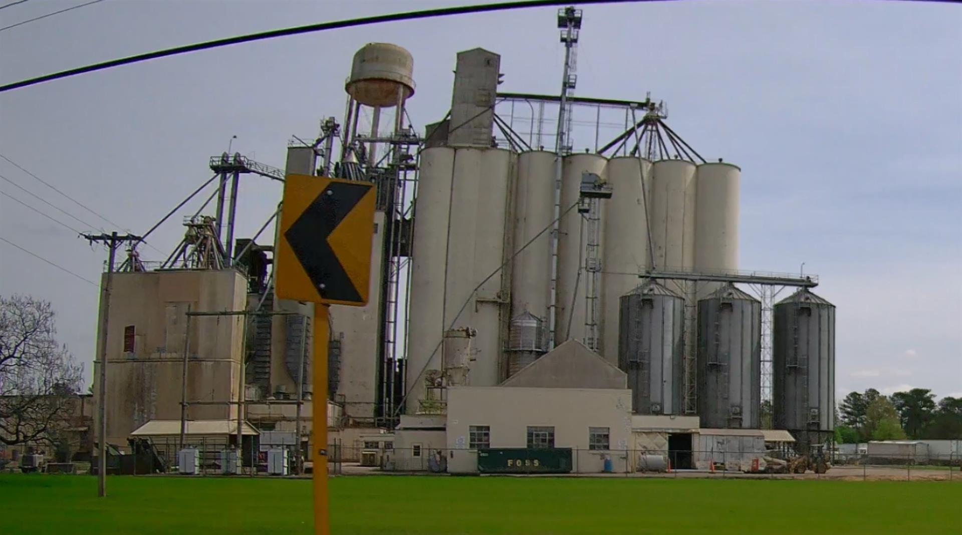
|
|
| Building
Sketch - NOTE: Sketches are updated the first day of every month. |
|
(Building 1) - Sketch for Parcel ID: 3721024925.000
NOTE: Sketches are updated the first day of every month.
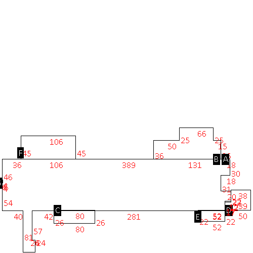 |
| Label |
Description |
Base SF |
Total SF |
| A |
INDUSTRIAL-LIGHT |
45218.00 |
45218.00 |
| B |
CANOPY-ECONOMY |
6366.00 |
.00 |
| C |
LOADING PLATFORM |
2080.00 |
.00 |
| D |
UTILITY STG-FR |
1686.00 |
.00 |
| E |
CANOPY-ECONOMY |
1144.00 |
.00 |
| F |
PATIO-CONC |
4770.00 |
.00 |
| G |
STOOP-MAS |
24.00 |
.00 |
|
|
(Building 2) - Sketch for Parcel ID: 3721024925.000
NOTE: Sketches are updated the first day of every month.
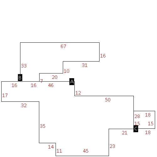 |
| Label |
Description |
Base SF |
Total SF |
| A |
INDUSTRIAL-LIGHT |
4347.00 |
4347.00 |
| B |
CANOPY-ECONOMY |
1544.00 |
.00 |
| C |
UTILITY STG-FR |
270.00 |
.00 |
|
|
(Building 3) - Sketch for Parcel ID: 3721024925.000
NOTE: Sketches are updated the first day of every month.
 |
| Label |
Description |
Base SF |
Total SF |
| A |
OFFICE BUILDING |
2764.00 |
2764.00 |
|
|
|
|
|
| Map Acres |
12.73 |
| Tax District Note |
31 - C/CIWI-WILSON |
| Present-Use Info |
INDUSTRIAL |
| Zoning Code |
LI |
| Zoning Desc |
LIGHT INDUSTRIAL |
|
| Total Improvements Valuation
|
*Total Improvements Full Market Value $
|
**Total Improvements Assessed Value
|
1,067,243
|
1,067,243
|
*
Note - Market Value effective Date equal January 1, 2024, date of County’s most recent General
Reappraisal
** Note - If Assessed Value not equal Market Value then variance
resulting from formal appeal procedure |
|
| Land
Value Detail (Effective Date January 1, 2024, date
of County’s most recent General Reappraisal) |
Land
Full Value (LFV) $
|
Land
Present-Use Value (PUV) $ **
|
Land
Total Assessed Value $
|
221,807
|
221,807
|
221,807
|
| **
Note: If PUV equal LMV then parcel has
not qualified for present use program |
|
| Land
Detail (Effective Date January 1, 2024, date of County’s
most recent General Reappraisal) |
Rate Type |
Rate Code |
Description |
Quantity |
SF |
0600 |
INDUSTRIAL |
554518.000 |
|
|
|
.000 |
|
|
|
|
