|
|
| 6231 MARK PL |
|
| WILSON , NC 27893-8918 |
|
| Property
Location Address |
|
| Parcel
ID No. |
3761480640.000 |
| PIN |
3761 48 0640 000 |
| Owner ID |
1094189 |
| |
|
| Tax
District |
25 - C/SW/BAKERTOWN FD |
| |
| Land Use Code |
50 |
| Land Use Desc |
RURAL HOMESITE |
| |
|
| Neighborhood |
8121 - GARDNERS |
|
| Legal
Desc |
6231 MARK PL |
| |
L1S1 MATTIE LEES CT .84AC |
| |
|
| Deed
Year Bk/Pg |
2017 - 2719 / 676 |
| Plat
Bk/Pg |
18 / 63 |
| |
Sales
Information |
| |
| Grantor |
STONE TERESA BULLOCK |
| |
|
| Sold
Date |
2017-10-20 |
| Sold
Amount $ |
0 |
|
| |
| Market Value $ |
149,088
|
| |
|
Market
Value - Land and all permanent improvements,
if any, effective January 1, 2024, date
of County’s most recent General Reappraisal
|
|
| |
|
| Assessed Value $ |
149,088
|
| |
If
Assessed Value not equal Market Value then
subject parcel designated as a special
class -agricultural, horticultural, or
forestland and thereby eligible for taxation
on basis of Present-Use.
|
|
|
| Year
Built |
1974 |
| Built
Use/Style |
SFR-UPTO 1.5 STY |
| Grade |
C+05 / C+05 GRADE |
| * Percent
Complete |
100 |
| Heated
Area (S/F) |
2,087 |
| Fireplace
(Y/N) |
Y |
| Basement
(Y/N) |
N |
| ** Bedroom(s) |
4 |
| ** Bathroom(s) |
2 Full Bath(s) 1 Half Bath(s) |
| *** Multiple
Improvements |
001 |
*
Note - As of January 1
*
* Note - Bathroom(s), Bedroom(s), shown for description
only
* * * Note - If multiple improvements equal “MLT” then
parcel includes additional major improvements |
|
| Photo |
Photo 1
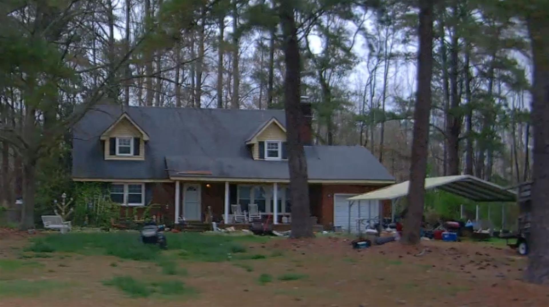
|
|
| Building
Sketch - NOTE: Sketches are updated the first day of every month. |
|
(Building 1) - Sketch for Parcel ID: 3761480640.000
NOTE: Sketches are updated the first day of every month.
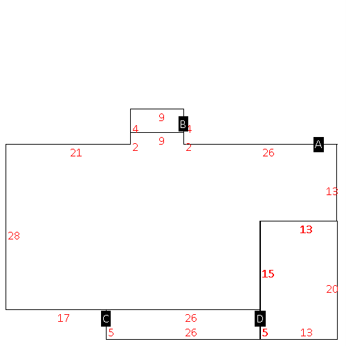 |
| Label |
Description |
Base SF |
Total SF |
| A |
SFR-1.5 STY |
1391.00 |
1391.00 |
| B |
STOOP-MAS |
36.00 |
.00 |
| C |
PORCH-OPEN-FR |
130.00 |
.00 |
| D |
GARAGE-ATT-FR |
260.00 |
.00 |
|
|
|
|
|
| Map Acres |
0.84 |
| Tax District Note |
25 - C/SW/BAKERTOWN FD |
| Present-Use Info |
RURAL HOMESITE |
| Zoning Code |
AR |
| Zoning Desc |
AGRICUL-RESID 40M SF |
|
| Total Improvements Valuation
|
*Total Improvements Full Market Value $
|
**Total Improvements Assessed Value
|
125,904
|
125,904
|
*
Note - Market Value effective Date equal January 1, 2024, date of County’s most recent General
Reappraisal
** Note - If Assessed Value not equal Market Value then variance
resulting from formal appeal procedure |
|
| Land
Value Detail (Effective Date January 1, 2024, date
of County’s most recent General Reappraisal) |
Land
Full Value (LFV) $
|
Land
Present-Use Value (PUV) $ **
|
Land
Total Assessed Value $
|
23,184
|
23,184
|
23,184
|
| **
Note: If PUV equal LMV then parcel has
not qualified for present use program |
|
| Land
Detail (Effective Date January 1, 2024, date of County’s
most recent General Reappraisal) |
Rate Type |
Rate Code |
Description |
Quantity |
AC |
5010 |
RURAL HOMESITE PAVED |
.840 |
|
|
|
.000 |
|
|
|
|
