| MCLAUGHLIN DONALD L TRUSTEE |
| MCLAUGHLIN CARRIE A TRUSTEE |
|
| 3713 SKYLINE DR |
|
| DES MOINES , IA 50310 |
|
| Property
Location Address |
|
| Parcel
ID No. |
3702496267.000 |
| PIN |
3702 49 6267 000 |
| Owner ID |
1078603 |
| |
|
| Tax
District |
13 - C/SW/CONTENTNEA FD |
| |
| Land Use Code |
01 |
| Land Use Desc |
SINGLE FAMILY RESIDENTIAL |
| |
|
| Neighborhood |
8243 - RALEIGH_ROAD_PKWY_A-1 |
|
| Legal
Desc |
4001 RALEIGH ROAD PKWY W |
| |
MORRIS TRACT 10.42AC |
| |
|
| Deed
Year Bk/Pg |
2010 - 2409 / 442 |
| Plat
Bk/Pg |
36 / 71 |
| |
Sales
Information |
| |
| Grantor |
|
| |
|
| Sold
Date |
0--0 |
| Sold
Amount $ |
0 |
|
| |
| Market Value $ |
585,234
|
| |
|
Market
Value - Land and all permanent improvements,
if any, effective January 1, 2024, date
of County’s most recent General Reappraisal
|
|
| |
|
| Assessed Value $ |
585,234
|
| |
If
Assessed Value not equal Market Value then
subject parcel designated as a special
class -agricultural, horticultural, or
forestland and thereby eligible for taxation
on basis of Present-Use.
|
|
|
| Year
Built |
1954 |
| Built
Use/Style |
SFR-1.0 STY W/ADDN |
| Grade |
C+10 / C+10 GRADE |
| * Percent
Complete |
100 |
| Heated
Area (S/F) |
2,646 |
| Fireplace
(Y/N) |
Y |
| Basement
(Y/N) |
N |
| ** Bedroom(s) |
3 |
| ** Bathroom(s) |
3 Full Bath(s) 0 Half Bath(s) |
| *** Multiple
Improvements |
004 |
*
Note - As of January 1
*
* Note - Bathroom(s), Bedroom(s), shown for description
only
* * * Note - If multiple improvements equal “MLT” then
parcel includes additional major improvements |
|
| Photo |
|
No Photo for 3702496267.000
|
|
| Building
Sketch - NOTE: Sketches are updated the first day of every month. |
|
(Building 1) - Sketch for Parcel ID: 3702496267.000
NOTE: Sketches are updated the first day of every month.
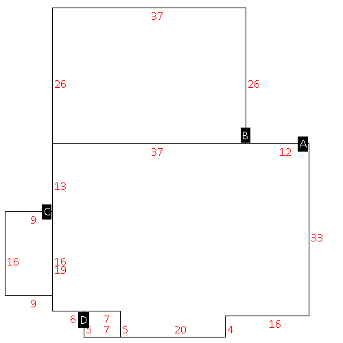 |
| Label |
Description |
Base SF |
Total SF |
| A |
SFR-1.0 STY |
1684.00 |
1684.00 |
| B |
SFR-ADDT FR |
962.00 |
962.00 |
| C |
PORCH-ENCL-FR |
144.00 |
.00 |
| D |
PORCH-OPEN-FR |
35.00 |
.00 |
|
|
(Building 2) - Sketch for Parcel ID: 3702496267.000
NOTE: Sketches are updated the first day of every month.
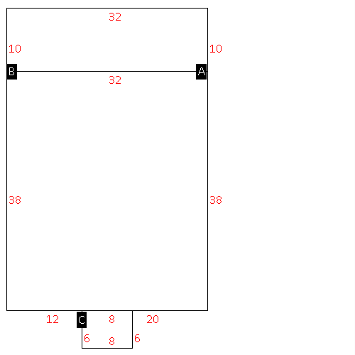 |
| Label |
Description |
Base SF |
Total SF |
| A |
SFR-1.0 STY |
1216.00 |
1216.00 |
| B |
PORCH-OPEN-FR |
320.00 |
.00 |
| C |
PORCH-OPEN-FR |
48.00 |
.00 |
|
|
(Building 3) - Sketch for Parcel ID: 3702496267.000
NOTE: Sketches are updated the first day of every month.
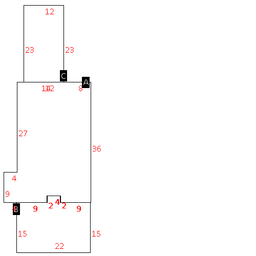 |
| Label |
Description |
Base SF |
Total SF |
| A |
COMMERCIAL-MISC |
820.00 |
820.00 |
| B |
CANOPY W/ SLAB |
338.00 |
.00 |
| C |
CANOPY-ROOF ONLY |
276.00 |
.00 |
|
|
(Building 4) - Sketch for Parcel ID: 3702496267.000
NOTE: Sketches are updated the first day of every month.
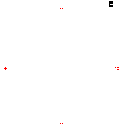 |
| Label |
Description |
Base SF |
Total SF |
| A |
APT-DUPLEX/TRIPLEX |
1440.00 |
2635.00 |
|
|
|
|
|
| Map Acres |
10.42 |
| Tax District Note |
13 - C/SW/CONTENTNEA FD |
| Present-Use Info |
SINGLE FAMILY RESIDENTIAL |
| Zoning Code |
RA |
| Zoning Desc |
RESIDENTAL AGRICULTURAL |
|
| Total Improvements Valuation
|
*Total Improvements Full Market Value $
|
**Total Improvements Assessed Value
|
284,937
|
284,937
|
*
Note - Market Value effective Date equal January 1, 2024, date of County’s most recent General
Reappraisal
** Note - If Assessed Value not equal Market Value then variance
resulting from formal appeal procedure |
|
| Land
Value Detail (Effective Date January 1, 2024, date
of County’s most recent General Reappraisal) |
Land
Full Value (LFV) $
|
Land
Present-Use Value (PUV) $ **
|
Land
Total Assessed Value $
|
300,297
|
300,297
|
300,297
|
| **
Note: If PUV equal LMV then parcel has
not qualified for present use program |
|
| Land
Detail (Effective Date January 1, 2024, date of County’s
most recent General Reappraisal) |
Rate Type |
Rate Code |
Description |
Quantity |
AC |
0700 |
COMMERCIAL |
5.000 |
|
|
|
.000 |
AC |
0121 |
RESIDUAL ACREAGE PAVED |
5.420 |
|
|
|
.000 |
|
|
|
|
