| WINSTEAD KENITH T TRUSTEE FOR |
| ALIJAH S KENDORIA WINSTEAD & |
|
| PO BOX 171 |
|
| SHARPSBURG , NC 27878 |
|
| Property
Location Address |
|
| Parcel
ID No. |
3747617375.000 |
| PIN |
3747 61 7375 000 |
| Owner ID |
1060316 |
| |
|
| Tax
District |
33 - C/CISP/SPMV-SHARPSBURG |
| |
| Land Use Code |
02 |
| Land Use Desc |
MANUFACTURED HOME (DW) |
| |
|
| Neighborhood |
8268 - SHARPSBURG |
|
| Legal
Desc |
121 B ST |
| |
L2 EASTWOOD SUB 1.00LT |
| |
|
| Deed
Year Bk/Pg |
2008 - 2315 / 200 |
| Plat
Bk/Pg |
23 / 136 |
| |
Sales
Information |
| |
| Grantor |
|
| |
|
| Sold
Date |
0--0 |
| Sold
Amount $ |
0 |
|
| |
| Market Value $ |
92,239
|
| |
|
Market
Value - Land and all permanent improvements,
if any, effective January 1, 2024, date
of County’s most recent General Reappraisal
|
|
| |
|
| Assessed Value $ |
92,239
|
| |
If
Assessed Value not equal Market Value then
subject parcel designated as a special
class -agricultural, horticultural, or
forestland and thereby eligible for taxation
on basis of Present-Use.
|
|
|
| Year
Built |
1990 |
| Built
Use/Style |
MH-DOUBLE WIDE |
| Grade |
C-05 / C-05 GRADE |
| * Percent
Complete |
100 |
| Heated
Area (S/F) |
1,458 |
| Fireplace
(Y/N) |
Y |
| Basement
(Y/N) |
N |
| ** Bedroom(s) |
3 |
| ** Bathroom(s) |
2 Full Bath(s) 0 Half Bath(s) |
| *** Multiple
Improvements |
001 |
*
Note - As of January 1
*
* Note - Bathroom(s), Bedroom(s), shown for description
only
* * * Note - If multiple improvements equal “MLT” then
parcel includes additional major improvements |
|
| Photo |
Photo 1
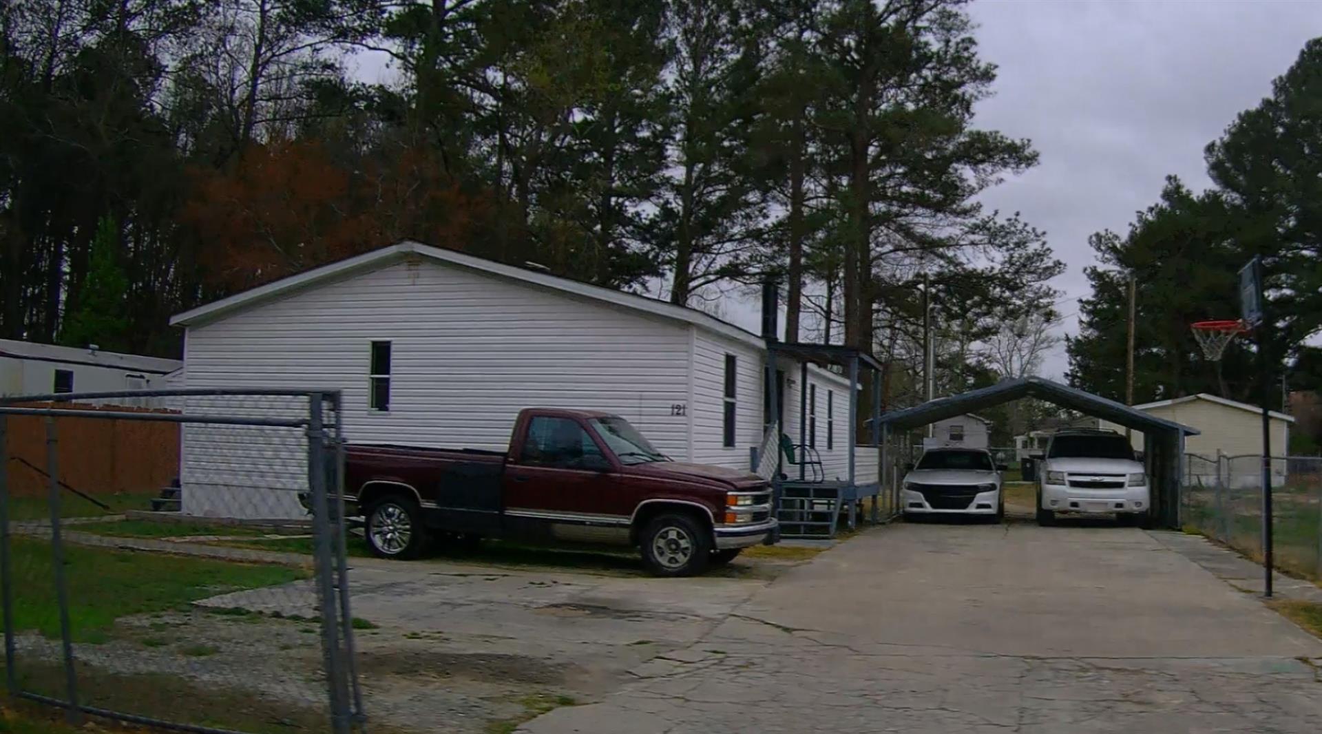
|
|
| Building
Sketch - NOTE: Sketches are updated the first day of every month. |
|
(Building 1) - Sketch for Parcel ID: 3747617375.000
NOTE: Sketches are updated the first day of every month.
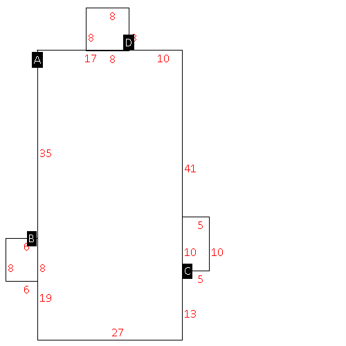 |
| Label |
Description |
Base SF |
Total SF |
| A |
MFG-DOUBLE WIDE |
1458.00 |
1458.00 |
| B |
DECK-WOOD |
48.00 |
.00 |
| C |
PORCH-OPEN-FR |
50.00 |
.00 |
| D |
DECK-WOOD |
64.00 |
.00 |
|
|
|
|
|
| Map Acres |
0.227 |
| Tax District Note |
33 - C/CISP/SPMV-SHARPSBURG |
| Present-Use Info |
MANUFACTURED HOME (DW) |
| Zoning Code |
R6 |
| Zoning Desc |
MH RES-SHARPSBURG |
|
| Total Improvements Valuation
|
*Total Improvements Full Market Value $
|
**Total Improvements Assessed Value
|
80,239
|
80,239
|
*
Note - Market Value effective Date equal January 1, 2024, date of County’s most recent General
Reappraisal
** Note - If Assessed Value not equal Market Value then variance
resulting from formal appeal procedure |
|
| Land
Value Detail (Effective Date January 1, 2024, date
of County’s most recent General Reappraisal) |
Land
Full Value (LFV) $
|
Land
Present-Use Value (PUV) $ **
|
Land
Total Assessed Value $
|
12,000
|
12,000
|
12,000
|
| **
Note: If PUV equal LMV then parcel has
not qualified for present use program |
|
| Land
Detail (Effective Date January 1, 2024, date of County’s
most recent General Reappraisal) |
Rate Type |
Rate Code |
Description |
Quantity |
LT |
0100 |
SINGLE FAMILY RESIDENTIAL |
1.000 |
|
|
|
.000 |
|
|
|
|
