| WILLOUGHBY ELIZABETH BARNES |
| |
|
| 7309 ROCK RIDGE SCHOOL RD |
|
| KENLY , NC 27542-9355 |
|
| Property
Location Address |
| 7037 ROCK RIDGE SCHOOL RD |
|
| Parcel
ID No. |
2771315926.000 |
| PIN |
2771 31 5926 000 |
| Owner ID |
1047108 |
| |
|
| Tax
District |
19 - C/SW/ROCK RIDGE FD |
| |
| Land Use Code |
50 |
| Land Use Desc |
RURAL HOMESITE |
| |
|
| Neighborhood |
8219 - OLD_FIELDS |
|
| Legal
Desc |
7037 ROCK RIDGE SCHOOL RD |
| |
TR-3 FREEMAN LD 39.00AC |
| |
|
| Deed
Year Bk/Pg |
2016 - 2646 / 97 |
| Plat
Bk/Pg |
1 / 90 |
| |
Sales
Information |
| |
| Grantor |
CHARLES LEWIS BARNES TRUST |
| |
|
| Sold
Date |
2016-02-23 |
| Sold
Amount $ |
0 |
|
| |
| Market Value $ |
249,197
|
| |
|
Market
Value - Land and all permanent improvements,
if any, effective January 1, 2024, date
of County’s most recent General Reappraisal
|
|
| |
|
| Assessed Value $ |
249,197
|
| |
If
Assessed Value not equal Market Value then
subject parcel designated as a special
class -agricultural, horticultural, or
forestland and thereby eligible for taxation
on basis of Present-Use.
|
|
|
| Year
Built |
1950 |
| Built
Use/Style |
SFR-1.0 STY |
| Grade |
C / C GRADE |
| * Percent
Complete |
100 |
| Heated
Area (S/F) |
1,498 |
| Fireplace
(Y/N) |
Y |
| Basement
(Y/N) |
N |
| ** Bedroom(s) |
2 |
| ** Bathroom(s) |
1 Full Bath(s) 0 Half Bath(s) |
| *** Multiple
Improvements |
001 |
*
Note - As of January 1
*
* Note - Bathroom(s), Bedroom(s), shown for description
only
* * * Note - If multiple improvements equal “MLT” then
parcel includes additional major improvements |
|
| Photo |
Photo 1
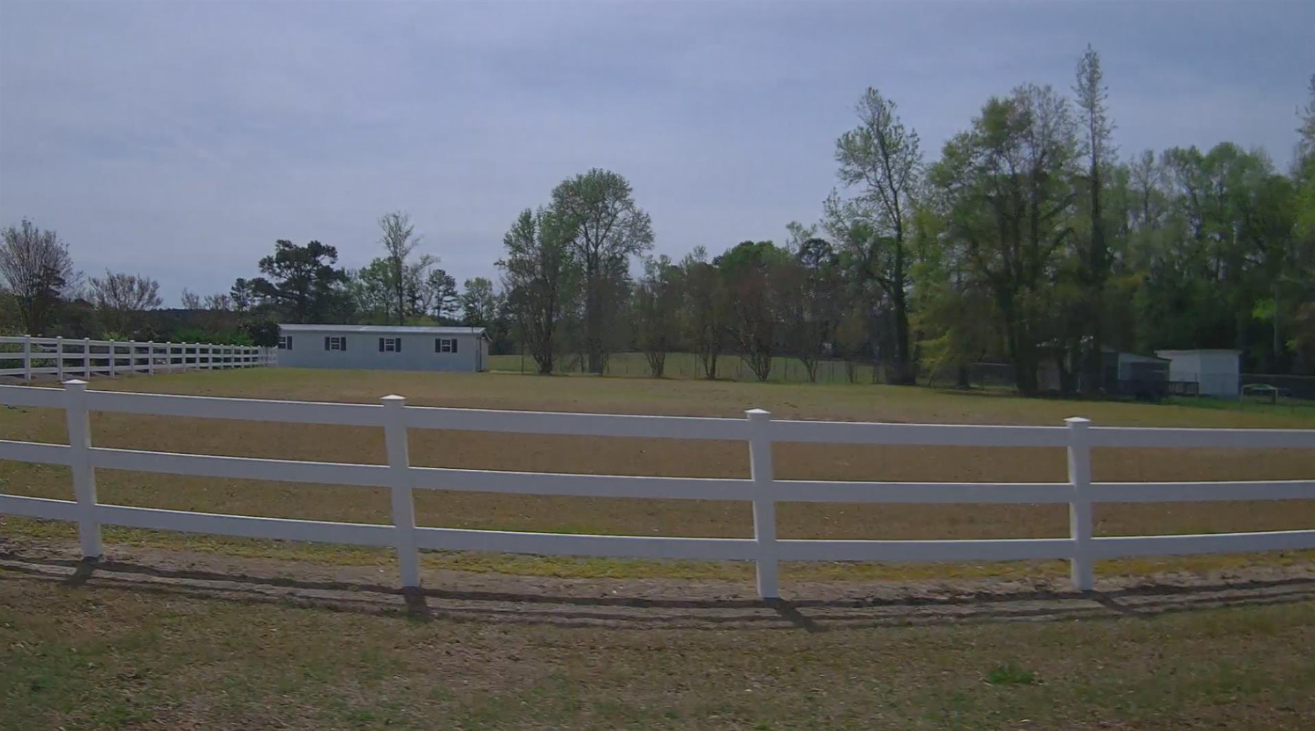 Photo 2
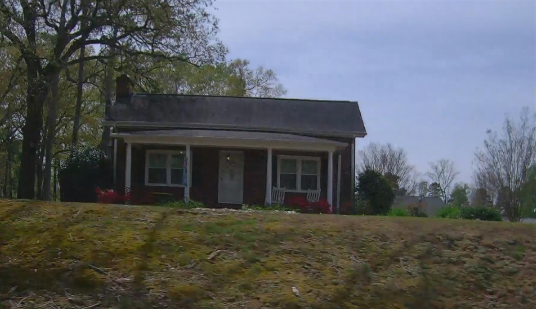
|
|
| Building
Sketch - NOTE: Sketches are updated the first day of every month. |
|
(Building 1) - Sketch for Parcel ID: 2771315926.000
NOTE: Sketches are updated the first day of every month.
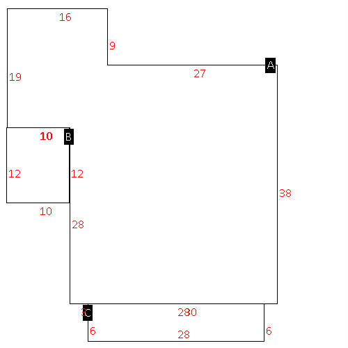 |
| Label |
Description |
Base SF |
Total SF |
| A |
SFR-1.0 STY |
1498.00 |
1498.00 |
| B |
DECK-WOOD |
120.00 |
.00 |
| C |
PORCH-OPEN-MAS |
168.00 |
.00 |
|
|
|
|
|
| Map Acres |
39 |
| Tax District Note |
19 - C/SW/ROCK RIDGE FD |
| Present-Use Info |
RURAL HOMESITE |
| Zoning Code |
AR |
| Zoning Desc |
AGRICUL-RESID 40M SF |
|
| Total Improvements Valuation
|
*Total Improvements Full Market Value $
|
**Total Improvements Assessed Value
|
131,249
|
131,249
|
*
Note - Market Value effective Date equal January 1, 2024, date of County’s most recent General
Reappraisal
** Note - If Assessed Value not equal Market Value then variance
resulting from formal appeal procedure |
|
| Land
Value Detail (Effective Date January 1, 2024, date
of County’s most recent General Reappraisal) |
Land
Full Value (LFV) $
|
Land
Present-Use Value (PUV) $ **
|
Land
Total Assessed Value $
|
117,948
|
117,948
|
117,948
|
| **
Note: If PUV equal LMV then parcel has
not qualified for present use program |
|
| Land
Detail (Effective Date January 1, 2024, date of County’s
most recent General Reappraisal) |
Rate Type |
Rate Code |
Description |
Quantity |
AC |
5010 |
RURAL HOMESITE PAVED |
1.000 |
|
|
|
.000 |
AC |
5111 |
MKT OPEN LD PVD CLASS 1 |
20.050 |
|
|
|
.000 |
AC |
6111 |
MKT WOODS PVD CLASS 1 |
16.050 |
|
|
|
.000 |
AC |
9500 |
SUBMERGED LAND, RIVERS,LK |
1.900 |
|
|
|
.000 |
|
|
|
|
