| STONE DANIEL STEPHEN |
| STONE STACI B |
|
| 3314 JENNINGS FARM DR NW |
|
| WILSON , NC 27896-8608 |
|
| Property
Location Address |
|
| Parcel
ID No. |
3702980620.000 |
| PIN |
3702 98 0620 000 |
| Owner ID |
1039963 |
| |
|
| Tax
District |
31 - C/CIWI-WILSON |
| |
| Land Use Code |
01 |
| Land Use Desc |
SINGLE FAMILY RESIDENTIAL |
| |
|
| Neighborhood |
8021 - BELLE_MEADE_WEST |
|
| Legal
Desc |
3314 JENNINGS FARM DR NW |
| |
L1S5 BELLE MEADE 1.00LT |
| |
|
| Deed
Year Bk/Pg |
2020 - 2836 / 643 |
| Plat
Bk/Pg |
21 / 26 |
| |
Sales
Information |
| |
| Grantor |
WILLIFORD CURTIS BUREN (HEIRS) |
| |
|
| Sold
Date |
2020-06-03 |
| Sold
Amount $ |
550,000 |
|
| |
| Market Value $ |
910,128
|
| |
|
Market
Value - Land and all permanent improvements,
if any, effective January 1, 2024, date
of County’s most recent General Reappraisal
|
|
| |
|
| Assessed Value $ |
910,128
|
| |
If
Assessed Value not equal Market Value then
subject parcel designated as a special
class -agricultural, horticultural, or
forestland and thereby eligible for taxation
on basis of Present-Use.
|
|
|
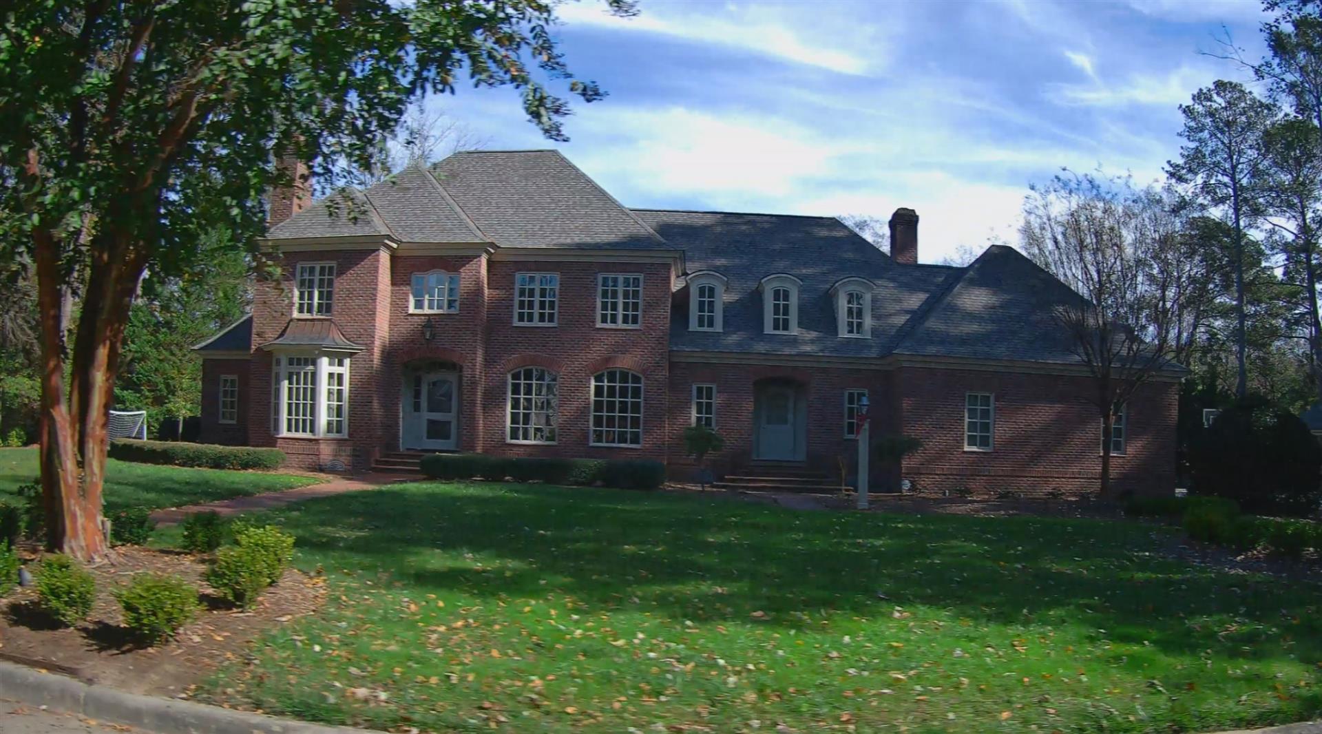
| Year
Built |
1996 |
| Built
Use/Style |
SFR-UPTO 2.0 STY |
| Grade |
A-05 / A-05 GRADE |
| * Percent
Complete |
100 |
| Heated
Area (S/F) |
5,479 |
| Fireplace
(Y/N) |
Y |
| Basement
(Y/N) |
N |
| ** Bedroom(s) |
4 |
| ** Bathroom(s) |
4 Full Bath(s) 2 Half Bath(s) |
| *** Multiple
Improvements |
001 |
*
Note - As of January 1
*
* Note - Bathroom(s), Bedroom(s), shown for description
only
* * * Note - If multiple improvements equal “MLT” then
parcel includes additional major improvements |
|
| Photo |
Photo 1
|
|
| Building
Sketch - NOTE: Sketches are updated the first day of every month. |
|
(Building 1) - Sketch for Parcel ID: 3702980620.000
NOTE: Sketches are updated the first day of every month.
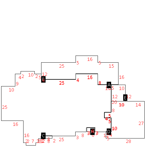 |
| Label |
Description |
Base SF |
Total SF |
| A |
SFR-2.0 STY |
3131.00 |
5479.00 |
| B |
DECK-WOOD |
748.00 |
.00 |
| C |
PORCH-OPEN-MAS |
16.00 |
.00 |
| D |
GARAGE-ATT-MAS |
688.00 |
.00 |
| E |
UTILITY STG-MAS |
120.00 |
.00 |
| H |
PORCH-OPEN-MAS |
18.00 |
.00 |
|
|
|
|
|
| Map Acres |
1.24 |
| Tax District Note |
31 - C/CIWI-WILSON |
| Present-Use Info |
SINGLE FAMILY RESIDENTIAL |
| Zoning Code |
SR4 |
| Zoning Desc |
SUB RES LOW DENSITY |
|
| Total Improvements Valuation
|
*Total Improvements Full Market Value $
|
**Total Improvements Assessed Value
|
802,128
|
802,128
|
*
Note - Market Value effective Date equal January 1, 2024, date of County’s most recent General
Reappraisal
** Note - If Assessed Value not equal Market Value then variance
resulting from formal appeal procedure |
|
| Land
Value Detail (Effective Date January 1, 2024, date
of County’s most recent General Reappraisal) |
Land
Full Value (LFV) $
|
Land
Present-Use Value (PUV) $ **
|
Land
Total Assessed Value $
|
108,000
|
108,000
|
108,000
|
| **
Note: If PUV equal LMV then parcel has
not qualified for present use program |
|
| Land
Detail (Effective Date January 1, 2024, date of County’s
most recent General Reappraisal) |
Rate Type |
Rate Code |
Description |
Quantity |
LT |
1101 |
SFR-PAVED-DEVELOPED |
1.500 |
|
|
|
.000 |
|
|
|
|
