| UNITED TOBACCO COMPANY LLC |
| |
|
| ATTN: JOE HOWE |
PO BOX 8205 |
| WILSON , NC 27894 |
|
| Property
Location Address |
|
| Parcel
ID No. |
3721528960.000 |
| PIN |
3721 52 8960 000 |
| Previous Parcel |
3721534044.000 |
| Owner ID |
69942176 |
| |
|
| Tax
District |
31 - C/CIWI-WILSON |
| |
| Land Use Code |
48 |
| Land Use Desc |
WAREHOUSE |
| |
|
| Neighborhood |
8344 - US_301-WARD_I-1 |
|
| Legal
Desc |
1510 STANTONSBURG RD SE |
| |
L2 73.36AC |
| |
|
| Deed
Year Bk/Pg |
2017 - 40 / 274 |
| Plat
Bk/Pg |
40 / 274 |
| |
Sales
Information |
| |
| Grantor |
|
| |
|
| Sold
Date |
0--0 |
| Sold
Amount $ |
0 |
|
| |
| Market Value $ |
11,959,376
|
| |
|
Market
Value - Land and all permanent improvements,
if any, effective January 1, 2024, date
of County’s most recent General Reappraisal
|
|
| |
|
| Assessed Value $ |
11,959,376
|
| |
If
Assessed Value not equal Market Value then
subject parcel designated as a special
class -agricultural, horticultural, or
forestland and thereby eligible for taxation
on basis of Present-Use.
|
|
|
| Year
Built |
2005 |
| Built
Use/Style |
WAREHOUSE |
| Grade |
C-05 / C-05 GRADE |
| * Percent
Complete |
100 |
| Heated
Area (S/F) |
125,000 |
| Fireplace
(Y/N) |
N |
| Basement
(Y/N) |
N |
| ** Bedroom(s) |
0 |
| ** Bathroom(s) |
0 Full Bath(s) 0 Half Bath(s) |
| *** Multiple
Improvements |
010 |
*
Note - As of January 1
*
* Note - Bathroom(s), Bedroom(s), shown for description
only
* * * Note - If multiple improvements equal “MLT” then
parcel includes additional major improvements |
|
| Photo |
Photo 1
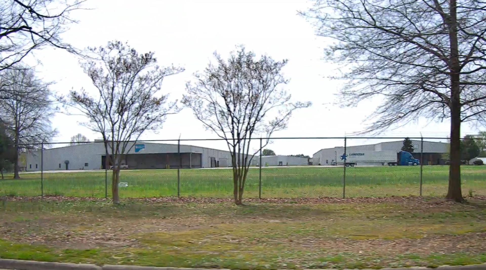
|
|
| Building
Sketch - NOTE: Sketches are updated the first day of every month. |
|
(Building 1) - Sketch for Parcel ID: 3721528960.000
NOTE: Sketches are updated the first day of every month.
 |
| Label |
Description |
Base SF |
Total SF |
| A |
WHSE |
17680.00 |
17680.00 |
| B |
CANOPY-ECONOMY |
252.00 |
.00 |
| C |
LOAD PLATFORM,CAN-ECONOMY |
1776.00 |
.00 |
| D |
CARPORT |
1950.00 |
.00 |
| E |
WHSE-OFFICE |
8208.00 |
8208.00 |
| F |
CANOPY-ECONOMY |
252.00 |
.00 |
| G |
LOAD PLATFORM,CAN-ECONOMY |
336.00 |
.00 |
|
|
(Building 2) - Sketch for Parcel ID: 3721528960.000
NOTE: Sketches are updated the first day of every month.
 |
| Label |
Description |
Base SF |
Total SF |
| A |
WHSE |
78920.00 |
78920.00 |
| B |
CARPORT |
5950.00 |
.00 |
| C |
TRUCK WELL |
1350.00 |
.00 |
| D |
TRUCK WELL |
1350.00 |
.00 |
| E |
WHSE-OFFICE |
1080.00 |
1080.00 |
|
|
(Building 3) - Sketch for Parcel ID: 3721528960.000
NOTE: Sketches are updated the first day of every month.
 |
| Label |
Description |
Base SF |
Total SF |
| A |
WHSE |
125000.00 |
125000.00 |
| B |
CARPORT |
4550.00 |
.00 |
| C |
TRUCK WELL |
1350.00 |
.00 |
| D |
TRUCK WELL |
1350.00 |
.00 |
| E |
TRUCK WELL |
1665.00 |
.00 |
|
|
(Building 4) - Sketch for Parcel ID: 3721528960.000
NOTE: Sketches are updated the first day of every month.
 |
| Label |
Description |
Base SF |
Total SF |
|
|
(Building 5) - Sketch for Parcel ID: 3721528960.000
NOTE: Sketches are updated the first day of every month.
 |
| Label |
Description |
Base SF |
Total SF |
|
|
(Building 6) - Sketch for Parcel ID: 3721528960.000
NOTE: Sketches are updated the first day of every month.
 |
| Label |
Description |
Base SF |
Total SF |
|
|
(Building 7) - Sketch for Parcel ID: 3721528960.000
NOTE: Sketches are updated the first day of every month.
 |
| Label |
Description |
Base SF |
Total SF |
|
|
(Building 8) - Sketch for Parcel ID: 3721528960.000
NOTE: Sketches are updated the first day of every month.
 |
| Label |
Description |
Base SF |
Total SF |
|
|
(Building 9) - Sketch for Parcel ID: 3721528960.000
NOTE: Sketches are updated the first day of every month.
 |
| Label |
Description |
Base SF |
Total SF |
|
|
(Building 10) - Sketch for Parcel ID: 3721528960.000
NOTE: Sketches are updated the first day of every month.
 |
| Label |
Description |
Base SF |
Total SF |
| A |
WHSE |
40000.00 |
40000.00 |
| C |
UTILITY STG-FR |
81.00 |
.00 |
|
|
|
|
|
| Map Acres |
73.36 |
| Tax District Note |
31 - C/CIWI-WILSON |
| Present-Use Info |
WAREHOUSE |
| Zoning Code |
LI |
| Zoning Desc |
LIGHT INDUSTRIAL |
|
| Total Improvements Valuation
|
*Total Improvements Full Market Value $
|
**Total Improvements Assessed Value
|
10,903,280
|
10,903,280
|
*
Note - Market Value effective Date equal January 1, 2024, date of County’s most recent General
Reappraisal
** Note - If Assessed Value not equal Market Value then variance
resulting from formal appeal procedure |
|
| Land
Value Detail (Effective Date January 1, 2024, date
of County’s most recent General Reappraisal) |
Land
Full Value (LFV) $
|
Land
Present-Use Value (PUV) $ **
|
Land
Total Assessed Value $
|
1,056,096
|
1,056,096
|
1,056,096
|
| **
Note: If PUV equal LMV then parcel has
not qualified for present use program |
|
| Land
Detail (Effective Date January 1, 2024, date of County’s
most recent General Reappraisal) |
Rate Type |
Rate Code |
Description |
Quantity |
AC |
0600 |
INDUSTRIAL |
30.000 |
|
|
|
.000 |
AC |
0121 |
RESIDUAL ACREAGE PAVED |
43.360 |
|
|
|
.000 |
|
|
|
|
