| SILVER LAKE GROWERS GIN LLC |
| |
|
| 6114 HWY 58 N |
|
| ELM CITY , NC 27822 |
|
| Property
Location Address |
|
| Parcel
ID No. |
3715782467.000 |
| PIN |
3715 78 2467 000 |
| Owner ID |
69941516 |
| |
|
| Tax
District |
14 - C/SW/SILVER LAKE FD |
| |
| Land Use Code |
40 |
| Land Use Desc |
INDUSTRIAL |
| |
|
| Neighborhood |
8311 - TAYLORS |
|
| Legal
Desc |
6114 NC 58 HWY N |
| |
11.36AC |
| |
|
| Deed
Year Bk/Pg |
2018 - 1761 / 273 |
| Plat
Bk/Pg |
41 / 175 |
| |
Sales
Information |
| |
| Grantor |
|
| |
|
| Sold
Date |
0--0 |
| Sold
Amount $ |
0 |
|
| |
| Market Value $ |
2,060,150
|
| |
|
Market
Value - Land and all permanent improvements,
if any, effective January 1, 2024, date
of County’s most recent General Reappraisal
|
|
| |
|
| Assessed Value $ |
2,060,150
|
| |
If
Assessed Value not equal Market Value then
subject parcel designated as a special
class -agricultural, horticultural, or
forestland and thereby eligible for taxation
on basis of Present-Use.
|
|
|
| Year
Built |
2020 |
| Built
Use/Style |
WAREHOUSE |
| Grade |
C / C GRADE |
| * Percent
Complete |
100 |
| Heated
Area (S/F) |
34,500 |
| Fireplace
(Y/N) |
N |
| Basement
(Y/N) |
N |
| ** Bedroom(s) |
0 |
| ** Bathroom(s) |
0 Full Bath(s) 0 Half Bath(s) |
| *** Multiple
Improvements |
005 |
*
Note - As of January 1
*
* Note - Bathroom(s), Bedroom(s), shown for description
only
* * * Note - If multiple improvements equal “MLT” then
parcel includes additional major improvements |
|
| Photo |
Photo 1
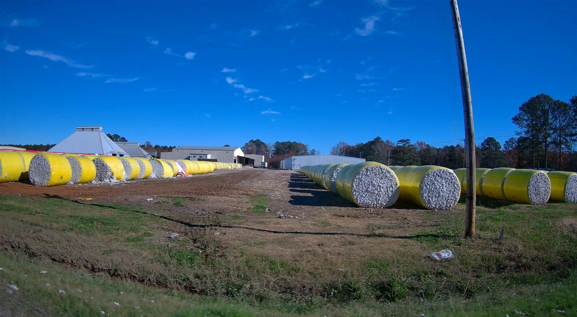 Photo 2

|
|
| Building
Sketch - NOTE: Sketches are updated the first day of every month. |
|
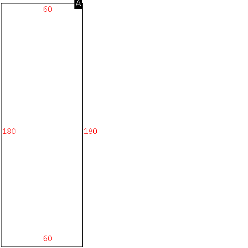
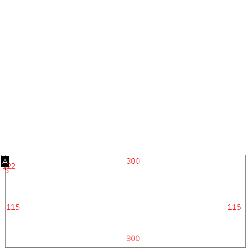
(Building 1) - Sketch for Parcel ID: 3715782467.000
NOTE: Sketches are updated the first day of every month.
 |
| Label |
Description |
Base SF |
Total SF |
| A |
INDUSTRIAL-LIGHT |
15625.00 |
15625.00 |
| B |
OFFICE BUILDING |
816.00 |
1632.00 |
| C |
LOAD PLATFORM,CAN-ECONOMY |
2160.00 |
.00 |
|
|
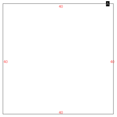
(Building 2) - Sketch for Parcel ID: 3715782467.000
NOTE: Sketches are updated the first day of every month.
 |
| Label |
Description |
Base SF |
Total SF |
| A |
WHSE |
10800.00 |
10800.00 |
|
|
(Building 3) - Sketch for Parcel ID: 3715782467.000
NOTE: Sketches are updated the first day of every month.
 |
| Label |
Description |
Base SF |
Total SF |
| A |
WHSE |
1600.00 |
1600.00 |
|
|
(Building 4) - Sketch for Parcel ID: 3715782467.000
NOTE: Sketches are updated the first day of every month.
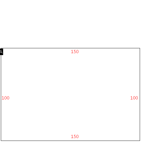 |
| Label |
Description |
Base SF |
Total SF |
| A |
WHSE |
15000.00 |
15000.00 |
|
|
(Building 5) - Sketch for Parcel ID: 3715782467.000
NOTE: Sketches are updated the first day of every month.
 |
| Label |
Description |
Base SF |
Total SF |
| A |
WHSE |
34500.00 |
34500.00 |
| B |
UTILITY STG-FR |
60.00 |
.00 |
|
|
|
|
|
| Map Acres |
11.36 |
| Tax District Note |
14 - C/SW/SILVER LAKE FD |
| Present-Use Info |
INDUSTRIAL |
| Zoning Code |
M1 |
| Zoning Desc |
LIGHT INDUSTRIAL 20/100 |
|
| Total Improvements Valuation
|
*Total Improvements Full Market Value $
|
**Total Improvements Assessed Value
|
1,882,086
|
1,882,086
|
*
Note - Market Value effective Date equal January 1, 2024, date of County’s most recent General
Reappraisal
** Note - If Assessed Value not equal Market Value then variance
resulting from formal appeal procedure |
|
| Land
Value Detail (Effective Date January 1, 2024, date
of County’s most recent General Reappraisal) |
Land
Full Value (LFV) $
|
Land
Present-Use Value (PUV) $ **
|
Land
Total Assessed Value $
|
178,064
|
178,064
|
178,064
|
| **
Note: If PUV equal LMV then parcel has
not qualified for present use program |
|
| Land
Detail (Effective Date January 1, 2024, date of County’s
most recent General Reappraisal) |
Rate Type |
Rate Code |
Description |
Quantity |
AC |
0600 |
INDUSTRIAL |
5.000 |
|
|
|
.000 |
AC |
0121 |
RESIDUAL ACREAGE PAVED |
6.360 |
|
|
|
.000 |
|
|
|
|
