| YELVERTON ROBERT L & JOAN C |
| BURKHART TERESA Y |
|
| 6843 MORNINGSIDE RD |
|
| FREMONT , NC 27830 |
|
| Property
Location Address |
|
| Parcel
ID No. |
3617638545.000 |
| PIN |
3617 63 8545 000 |
| Owner ID |
69932917 |
| |
|
| Tax
District |
16 - C/SW/LEE WOODARD FD |
| |
| Land Use Code |
50 |
| Land Use Desc |
RURAL HOMESITE |
| |
|
| Neighborhood |
8031 - BLACK_CREEK_TWP |
|
| Legal
Desc |
6843 MORNINGSIDE RD |
| |
64.00AC |
| |
|
| Deed
Year Bk/Pg |
1996 - 1593 / 821 |
| Plat
Bk/Pg |
/ |
| |
Sales
Information |
| |
| Grantor |
|
| |
|
| Sold
Date |
0--0 |
| Sold
Amount $ |
0 |
|
| |
| Market Value $ |
262,046
|
| |
|
Market
Value - Land and all permanent improvements,
if any, effective January 1, 2024, date
of County’s most recent General Reappraisal
|
|
| |
|
| Assessed Value $ |
167,805
|
| |
If
Assessed Value not equal Market Value then
subject parcel designated as a special
class -agricultural, horticultural, or
forestland and thereby eligible for taxation
on basis of Present-Use.
|
|
|
| Year
Built |
1935 |
| Built
Use/Style |
SFR-1.0 STY |
| Grade |
C / C GRADE |
| * Percent
Complete |
100 |
| Heated
Area (S/F) |
1,829 |
| Fireplace
(Y/N) |
Y |
| Basement
(Y/N) |
N |
| ** Bedroom(s) |
3 |
| ** Bathroom(s) |
1 Full Bath(s) 0 Half Bath(s) |
| *** Multiple
Improvements |
001 |
*
Note - As of January 1
*
* Note - Bathroom(s), Bedroom(s), shown for description
only
* * * Note - If multiple improvements equal “MLT” then
parcel includes additional major improvements |
|
| Photo |
Photo 1

|
|
| Building
Sketch - NOTE: Sketches are updated the first day of every month. |
|
(Building 1) - Sketch for Parcel ID: 3617638545.000
NOTE: Sketches are updated the first day of every month.
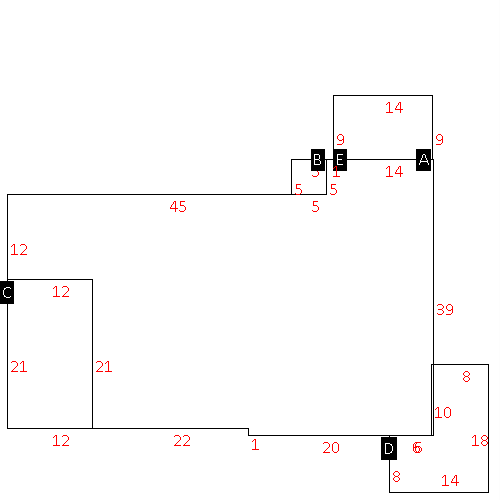 |
| Label |
Description |
Base SF |
Total SF |
| A |
SFR-1.0 STY |
1829.00 |
1829.00 |
| B |
UTILITY STG-FR |
25.00 |
.00 |
| C |
PATIO-CONC |
252.00 |
.00 |
| D |
PORCH-OPEN-MAS |
192.00 |
.00 |
| E |
PATIO-CONC |
126.00 |
.00 |
|
|
|
|
|
| Map Acres |
64 |
| Tax District Note |
16 - C/SW/LEE WOODARD FD |
| Present-Use Info |
RURAL HOMESITE |
| Zoning Code |
AR |
| Zoning Desc |
AGRICUL-RESID 40M SF |
|
| Total Improvements Valuation
|
*Total Improvements Full Market Value $
|
**Total Improvements Assessed Value
|
116,301
|
116,301
|
*
Note - Market Value effective Date equal January 1, 2024, date of County’s most recent General
Reappraisal
** Note - If Assessed Value not equal Market Value then variance
resulting from formal appeal procedure |
|
| Land
Value Detail (Effective Date January 1, 2024, date
of County’s most recent General Reappraisal) |
Land
Full Value (LFV) $
|
Land
Present-Use Value (PUV) $ **
|
Land
Total Assessed Value $
|
145,745
|
51,504
|
51,504
|
| **
Note: If PUV equal LMV then parcel has
not qualified for present use program |
|
| Land
Detail (Effective Date January 1, 2024, date of County’s
most recent General Reappraisal) |
Rate Type |
Rate Code |
Description |
Quantity |
AC |
5411 |
MKT OPEN LD PVD CLASS 4 |
5.500 |
LU |
5410 |
|
5.500 |
AC |
5611 |
MKT OPEN LD PVD CLASS 6 |
2.100 |
LU |
5610 |
|
2.100 |
AC |
6211 |
MKT WOODS PVD CLASS 2 |
12.500 |
LU |
6210 |
|
12.500 |
AC |
6411 |
MKT WOODS PVD CLASS 4 |
12.900 |
LU |
6410 |
|
12.900 |
AC |
5010 |
RURAL HOMESITE PAVED |
1.000 |
|
|
|
.000 |
AC |
5211 |
MKT OPEN LD PVD CLASS 2 |
30.000 |
LU |
5210 |
|
30.000 |
|
|
|
|
