| BOYD GEORGE WATKINS |
| BOYD LYNN SHINGLETON |
|
| 3424 M L KING JR PW SE |
|
| WILSON , NC 27893-7662 |
|
| Property
Location Address |
|
| Parcel
ID No. |
3647977769.000 |
| PIN |
3647 97 7769 000 |
| Owner ID |
69912946 |
| |
|
| Tax
District |
30 - C/CIST/FMO-STANTONSBURG |
| |
| Land Use Code |
10 |
| Land Use Desc |
COMMERICAL |
| |
|
| Neighborhood |
8292 - STANTONSBURG_C |
|
| Legal
Desc |
102 E COMMERCIAL AVE |
| |
BK-6 P2 1.00LT |
| |
|
| Deed
Year Bk/Pg |
2017 - 2707 / 880 |
| Plat
Bk/Pg |
1 / 198 |
| |
Sales
Information |
| |
| Grantor |
DAVIS TAMMY BAGLEY |
| |
|
| Sold
Date |
2017-07-19 |
| Sold
Amount $ |
2,500 |
|
| |
| Market Value $ |
7,171
|
| |
|
Market
Value - Land and all permanent improvements,
if any, effective January 1, 2024, date
of County’s most recent General Reappraisal
|
|
| |
|
| Assessed Value $ |
7,171
|
| |
If
Assessed Value not equal Market Value then
subject parcel designated as a special
class -agricultural, horticultural, or
forestland and thereby eligible for taxation
on basis of Present-Use.
|
|
|
| Year
Built |
1910 |
| Built
Use/Style |
COMMERCIAL |
| Grade |
D+05 / D+05 GRADE |
| * Percent
Complete |
100 |
| Heated
Area (S/F) |
1,512 |
| Fireplace
(Y/N) |
N |
| Basement
(Y/N) |
N |
| ** Bedroom(s) |
0 |
| ** Bathroom(s) |
0 Full Bath(s) 0 Half Bath(s) |
| *** Multiple
Improvements |
001 |
*
Note - As of January 1
*
* Note - Bathroom(s), Bedroom(s), shown for description
only
* * * Note - If multiple improvements equal “MLT” then
parcel includes additional major improvements |
|
| Photo |
Photo 1
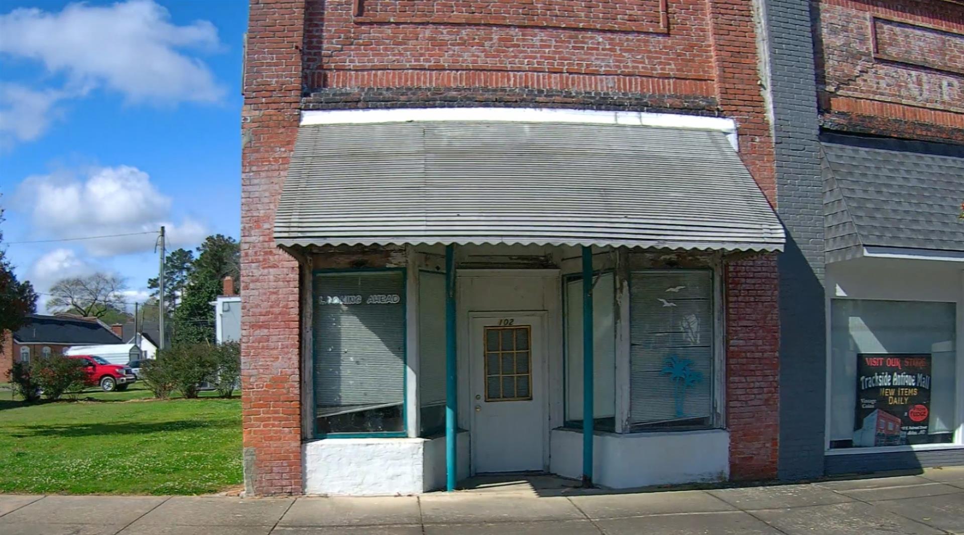
|
|
| Building
Sketch - NOTE: Sketches are updated the first day of every month. |
|
(Building 1) - Sketch for Parcel ID: 3647977769.000
NOTE: Sketches are updated the first day of every month.
 |
| Label |
Description |
Base SF |
Total SF |
| A |
COMMERCIAL-MISC |
1512.00 |
1512.00 |
| B |
CANOPY W/ SLAB |
85.00 |
.00 |
|
|
|
|
|
| Map Acres |
0.036 |
| Tax District Note |
30 - C/CIST/FMO-STANTONSBURG |
| Present-Use Info |
COMMERICAL |
| Zoning Code |
C |
| Zoning Desc |
COMMERCIAL-STANTONSBURG |
|
| Total Improvements Valuation
|
*Total Improvements Full Market Value $
|
**Total Improvements Assessed Value
|
5,176
|
5,176
|
*
Note - Market Value effective Date equal January 1, 2024, date of County’s most recent General
Reappraisal
** Note - If Assessed Value not equal Market Value then variance
resulting from formal appeal procedure |
|
| Land
Value Detail (Effective Date January 1, 2024, date
of County’s most recent General Reappraisal) |
Land
Full Value (LFV) $
|
Land
Present-Use Value (PUV) $ **
|
Land
Total Assessed Value $
|
1,995
|
1,995
|
1,995
|
| **
Note: If PUV equal LMV then parcel has
not qualified for present use program |
|
| Land
Detail (Effective Date January 1, 2024, date of County’s
most recent General Reappraisal) |
Rate Type |
Rate Code |
Description |
Quantity |
SF |
0700 |
COMMERCIAL |
1596.000 |
|
|
|
.000 |
|
|
|
|
