| HARVEY FERTILIZER & GAS CO |
| |
|
| PO BOX 189 |
|
| KINSTON , NC 28501-0189 |
|
| Property
Location Address |
|
| Parcel
ID No. |
3733966214.000 |
| PIN |
3733 96 6214 000 |
| Owner ID |
190294505 |
| |
|
| Tax
District |
23 - C/SW/TOISNOT FD |
| |
| Land Use Code |
17 |
| Land Use Desc |
OFFICE |
| |
|
| Neighborhood |
8334 - TOISNOT_US_301_B-1 |
|
| Legal
Desc |
4231 ROSEBUD CHURCH RD |
| |
TR-2 6.57AC |
| |
|
| Deed
Year Bk/Pg |
1999 - 1747 / 459 |
| Plat
Bk/Pg |
17 / 34 |
| |
Sales
Information |
| |
| Grantor |
|
| |
|
| Sold
Date |
0--0 |
| Sold
Amount $ |
0 |
|
| |
| Market Value $ |
906,254
|
| |
|
Market
Value - Land and all permanent improvements,
if any, effective January 1, 2024, date
of County’s most recent General Reappraisal
|
|
| |
|
| Assessed Value $ |
906,254
|
| |
If
Assessed Value not equal Market Value then
subject parcel designated as a special
class -agricultural, horticultural, or
forestland and thereby eligible for taxation
on basis of Present-Use.
|
|
|
| Year
Built |
2000 |
| Built
Use/Style |
WAREHOUSE |
| Grade |
C-05 / C-05 GRADE |
| * Percent
Complete |
100 |
| Heated
Area (S/F) |
14,100 |
| Fireplace
(Y/N) |
N |
| Basement
(Y/N) |
N |
| ** Bedroom(s) |
0 |
| ** Bathroom(s) |
0 Full Bath(s) 0 Half Bath(s) |
| *** Multiple
Improvements |
003 |
*
Note - As of January 1
*
* Note - Bathroom(s), Bedroom(s), shown for description
only
* * * Note - If multiple improvements equal “MLT” then
parcel includes additional major improvements |
|
| Photo |
Photo 1

|
|
| Building
Sketch - NOTE: Sketches are updated the first day of every month. |
|
(Building 1) - Sketch for Parcel ID: 3733966214.000
NOTE: Sketches are updated the first day of every month.
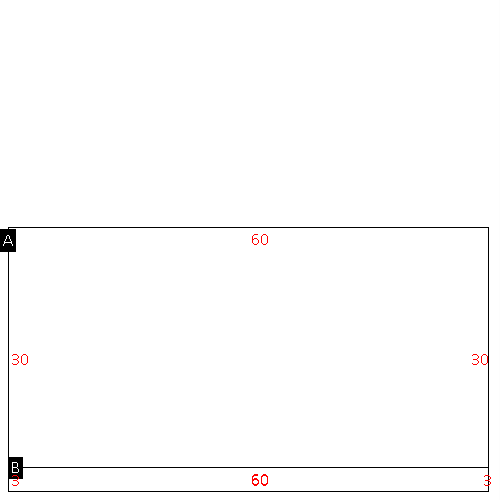 |
| Label |
Description |
Base SF |
Total SF |
| A |
OFFICE BUILDING |
1800.00 |
1800.00 |
| B |
CANOPY-ECONOMY |
180.00 |
.00 |
|
|
(Building 2) - Sketch for Parcel ID: 3733966214.000
NOTE: Sketches are updated the first day of every month.
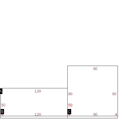 |
| Label |
Description |
Base SF |
Total SF |
| A |
WHSE |
6000.00 |
6000.00 |
| B |
CANOPY W/ SLAB |
480.00 |
.00 |
| C |
WHSE |
8100.00 |
8100.00 |
| D |
CANOPY W/ SLAB |
360.00 |
.00 |
|
|
(Building 3) - Sketch for Parcel ID: 3733966214.000
NOTE: Sketches are updated the first day of every month.
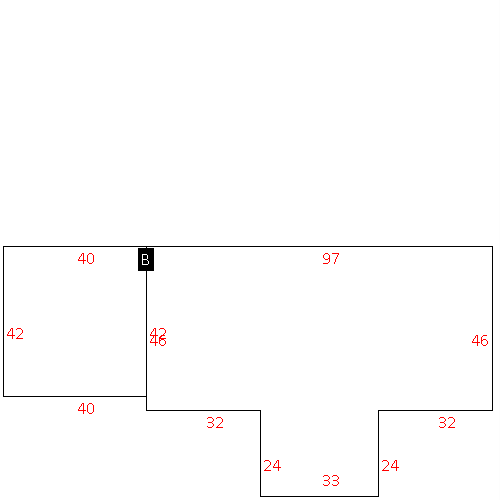 |
| Label |
Description |
Base SF |
Total SF |
| A |
WHSE |
5254.00 |
5254.00 |
| B |
WHSE |
1680.00 |
1680.00 |
|
|
|
|
|
| Map Acres |
6.57 |
| Tax District Note |
23 - C/SW/TOISNOT FD |
| Present-Use Info |
OFFICE |
| Zoning Code |
B1-CD |
| Zoning Desc |
BUS-COMM DEV |
|
| Total Improvements Valuation
|
*Total Improvements Full Market Value $
|
**Total Improvements Assessed Value
|
620,065
|
620,065
|
*
Note - Market Value effective Date equal January 1, 2024, date of County’s most recent General
Reappraisal
** Note - If Assessed Value not equal Market Value then variance
resulting from formal appeal procedure |
|
| Land
Value Detail (Effective Date January 1, 2024, date
of County’s most recent General Reappraisal) |
Land
Full Value (LFV) $
|
Land
Present-Use Value (PUV) $ **
|
Land
Total Assessed Value $
|
286,189
|
286,189
|
286,189
|
| **
Note: If PUV equal LMV then parcel has
not qualified for present use program |
|
| Land
Detail (Effective Date January 1, 2024, date of County’s
most recent General Reappraisal) |
Rate Type |
Rate Code |
Description |
Quantity |
SF |
0700 |
COMMERCIAL |
286189.000 |
|
|
|
.000 |
|
|
|
|
