| ELLIS MARY E & BRIAN L |
| EDWARD JEAN E |
|
| 1032 RED OAK RD |
|
| NASHVILLE , NC 27856-9771 |
|
| Property
Location Address |
|
| Parcel
ID No. |
3733512349.000 |
| PIN |
3733 51 2349 000 |
| Previous Parcel |
3733511782.000 |
| Owner ID |
1108435 |
| |
|
| Tax
District |
31 - C/CIWI-WILSON |
| |
| Land Use Code |
40 |
| Land Use Desc |
INDUSTRIAL |
| |
|
| Neighborhood |
8114 - FIRESTONE_PKWY |
|
| Legal
Desc |
2356 FIRESTONE PKWY NE |
| |
5.55AC |
| |
|
| Deed
Year Bk/Pg |
2016 - 2016 / WILL |
| Plat
Bk/Pg |
37 / 246 |
| |
Sales
Information |
| |
| Grantor |
ELLIS OSCAR W JR (HEIRS) |
| |
EDWARDS JEAN E |
| Sold
Date |
2016-12-31 |
| Sold
Amount $ |
0 |
|
| |
| Market Value $ |
703,799
|
| |
|
Market
Value - Land and all permanent improvements,
if any, effective January 1, 2024, date
of County’s most recent General Reappraisal
|
|
| |
|
| Assessed Value $ |
703,799
|
| |
If
Assessed Value not equal Market Value then
subject parcel designated as a special
class -agricultural, horticultural, or
forestland and thereby eligible for taxation
on basis of Present-Use.
|
|
|
| Year
Built |
1987 |
| Built
Use/Style |
INDUSTRIAL |
| Grade |
C-10 / C-10 GRADE |
| * Percent
Complete |
100 |
| Heated
Area (S/F) |
28,125 |
| Fireplace
(Y/N) |
N |
| Basement
(Y/N) |
N |
| ** Bedroom(s) |
0 |
| ** Bathroom(s) |
0 Full Bath(s) 0 Half Bath(s) |
| *** Multiple
Improvements |
002 |
*
Note - As of January 1
*
* Note - Bathroom(s), Bedroom(s), shown for description
only
* * * Note - If multiple improvements equal “MLT” then
parcel includes additional major improvements |
|
| Photo |
Photo 1

|
|
| Building
Sketch - NOTE: Sketches are updated the first day of every month. |
|
(Building 1) - Sketch for Parcel ID: 3733512349.000
NOTE: Sketches are updated the first day of every month.
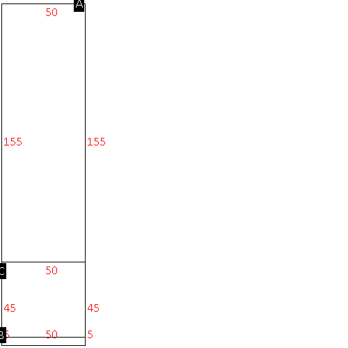 |
| Label |
Description |
Base SF |
Total SF |
| A |
INDUSTRIAL-LIGHT |
7750.00 |
7750.00 |
| B |
CANOPY W/ SLAB |
250.00 |
.00 |
| C |
OFFICE BUILDING |
2250.00 |
2250.00 |
|
|
(Building 2) - Sketch for Parcel ID: 3733512349.000
NOTE: Sketches are updated the first day of every month.
 |
| Label |
Description |
Base SF |
Total SF |
|
|
|
|
|
| Map Acres |
5.55 |
| Tax District Note |
31 - C/CIWI-WILSON |
| Present-Use Info |
INDUSTRIAL |
| Zoning Code |
HI |
| Zoning Desc |
HEAVY INDUSTRIAL |
|
| Total Improvements Valuation
|
*Total Improvements Full Market Value $
|
**Total Improvements Assessed Value
|
611,714
|
611,714
|
*
Note - Market Value effective Date equal January 1, 2024, date of County’s most recent General
Reappraisal
** Note - If Assessed Value not equal Market Value then variance
resulting from formal appeal procedure |
|
| Land
Value Detail (Effective Date January 1, 2024, date
of County’s most recent General Reappraisal) |
Land
Full Value (LFV) $
|
Land
Present-Use Value (PUV) $ **
|
Land
Total Assessed Value $
|
92,085
|
92,085
|
92,085
|
| **
Note: If PUV equal LMV then parcel has
not qualified for present use program |
|
| Land
Detail (Effective Date January 1, 2024, date of County’s
most recent General Reappraisal) |
Rate Type |
Rate Code |
Description |
Quantity |
AC |
0600 |
INDUSTRIAL |
3.000 |
|
|
|
.000 |
AC |
0121 |
RESIDUAL ACREAGE PAVED |
2.550 |
|
|
|
.000 |
|
|
|
|
