| BLACK STONE ENTERPRISE LLC |
| |
|
| PO BOX 2712 |
|
| WILSON , NC 27894-2712 |
|
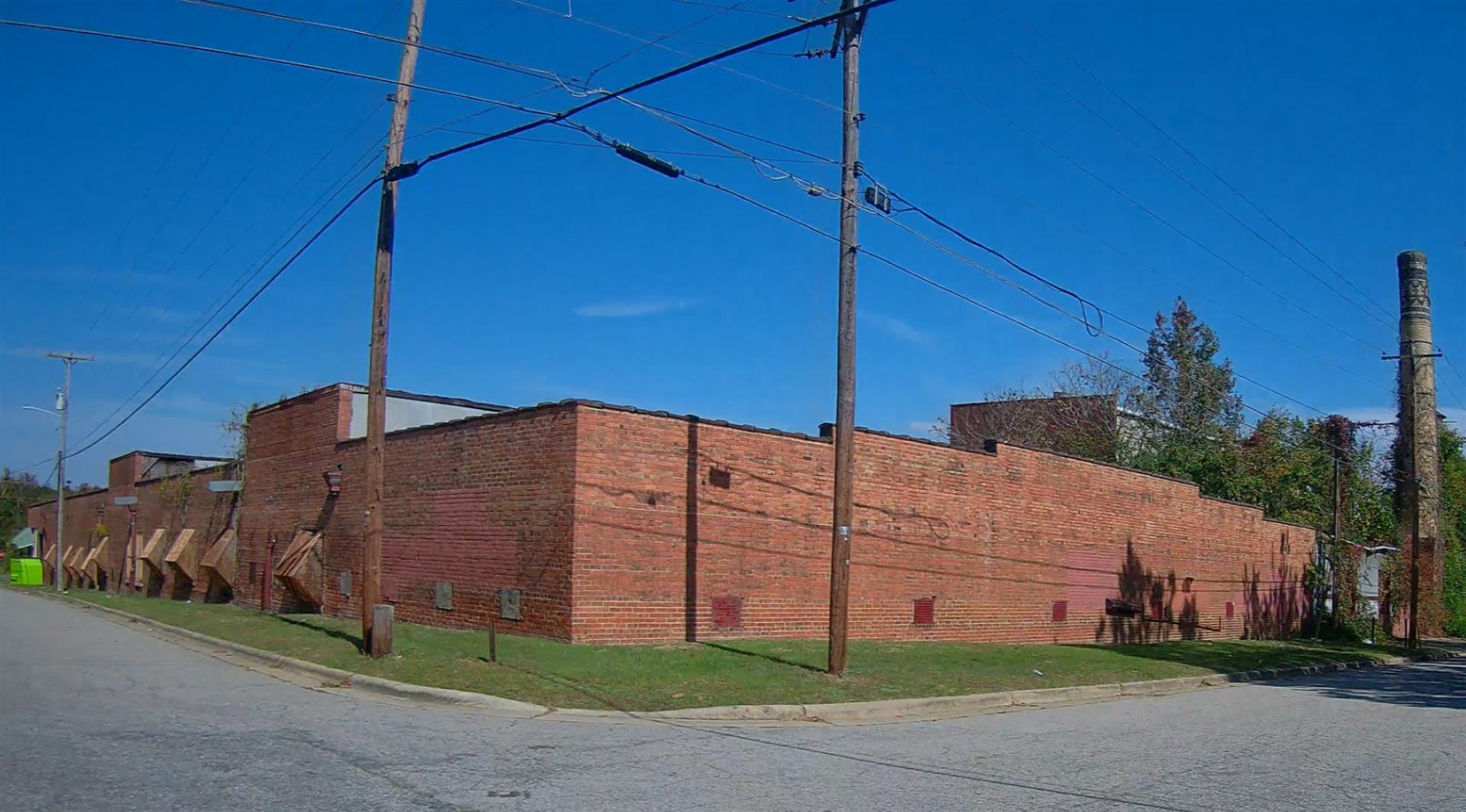
| Property
Location Address |
|
| Parcel
ID No. |
3721185766.000 |
| PIN |
3721 18 5766 000 |
| Owner ID |
1107706 |
| |
|
| Tax
District |
31 - C/CIWI-WILSON |
| |
| Land Use Code |
48 |
| Land Use Desc |
WAREHOUSE |
| |
|
| Neighborhood |
8125 - GOLDSBORO-SPRUCE_I-1 |
|
| Legal
Desc |
611 GOLDSBORO ST S |
| |
PLT & STG 1.93AC |
| |
|
| Deed
Year Bk/Pg |
2023 - 3034 / 952 |
| Plat
Bk/Pg |
/ |
| |
Sales
Information |
| |
| Grantor |
TRI AND SEABASS LLC |
| |
|
| Sold
Date |
2023-10-03 |
| Sold
Amount $ |
250,000 |
|
| |
| Market Value $ |
290,618
|
| |
|
Market
Value - Land and all permanent improvements,
if any, effective January 1, 2024, date
of County’s most recent General Reappraisal
|
|
| |
|
| Assessed Value $ |
290,618
|
| |
If
Assessed Value not equal Market Value then
subject parcel designated as a special
class -agricultural, horticultural, or
forestland and thereby eligible for taxation
on basis of Present-Use.
|
|
|
| Year
Built |
1950 |
| Built
Use/Style |
WAREHOUSE |
| Grade |
C+05 / C+05 GRADE |
| * Percent
Complete |
100 |
| Heated
Area (S/F) |
36,204 |
| Fireplace
(Y/N) |
N |
| Basement
(Y/N) |
N |
| ** Bedroom(s) |
0 |
| ** Bathroom(s) |
0 Full Bath(s) 0 Half Bath(s) |
| *** Multiple
Improvements |
002 |
*
Note - As of January 1
*
* Note - Bathroom(s), Bedroom(s), shown for description
only
* * * Note - If multiple improvements equal “MLT” then
parcel includes additional major improvements |
|
| Photo |
Photo 1
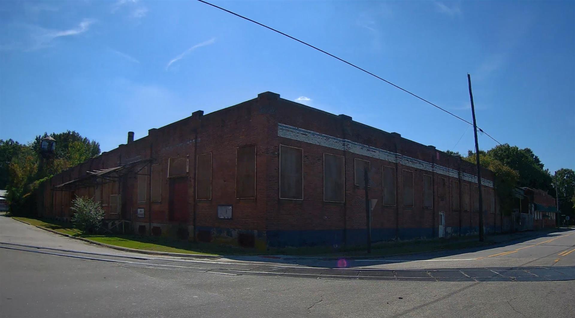 Photo 2
|
|
| Building
Sketch - NOTE: Sketches are updated the first day of every month. |
|
(Building 1) - Sketch for Parcel ID: 3721185766.000
NOTE: Sketches are updated the first day of every month.
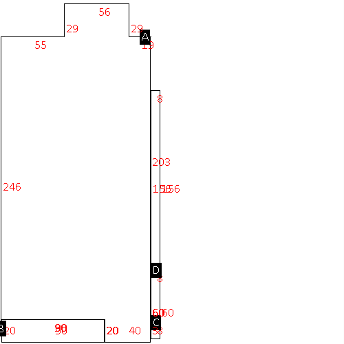 |
| Label |
Description |
Base SF |
Total SF |
| A |
WHSE |
34404.00 |
34404.00 |
| B |
OFFICE BUILDING |
1800.00 |
1800.00 |
| C |
CANOPY-ECONOMY |
480.00 |
.00 |
| D |
UNCOV LOAD PLATFORM-AVG |
1248.00 |
.00 |
|
|
(Building 2) - Sketch for Parcel ID: 3721185766.000
NOTE: Sketches are updated the first day of every month.
 |
| Label |
Description |
Base SF |
Total SF |
| A |
WHSE |
31605.00 |
31605.00 |
| B |
UTILITY STG-FR |
840.00 |
.00 |
| C |
UNCOV LOAD PLATFORM-AVG |
1224.00 |
.00 |
| D |
CANOPY-ECONOMY |
480.00 |
.00 |
|
|
|
|
|
| Map Acres |
1.93 |
| Tax District Note |
31 - C/CIWI-WILSON |
| Present-Use Info |
WAREHOUSE |
| Zoning Code |
IMX |
| Zoning Desc |
INDUSTRIAL MIXED USE |
|
| Total Improvements Valuation
|
*Total Improvements Full Market Value $
|
**Total Improvements Assessed Value
|
247,742
|
247,742
|
*
Note - Market Value effective Date equal January 1, 2024, date of County’s most recent General
Reappraisal
** Note - If Assessed Value not equal Market Value then variance
resulting from formal appeal procedure |
|
| Land
Value Detail (Effective Date January 1, 2024, date
of County’s most recent General Reappraisal) |
Land
Full Value (LFV) $
|
Land
Present-Use Value (PUV) $ **
|
Land
Total Assessed Value $
|
42,876
|
42,876
|
42,876
|
| **
Note: If PUV equal LMV then parcel has
not qualified for present use program |
|
| Land
Detail (Effective Date January 1, 2024, date of County’s
most recent General Reappraisal) |
Rate Type |
Rate Code |
Description |
Quantity |
SF |
0648 |
WAREHOUSING |
84071.000 |
|
|
|
.000 |
|
|
|
|
