| J&B TYNER FAMILY FARMS LLC |
| |
|
| 7853 PROCTOR PL |
|
| ELM CITY , NC 27822 |
|
| Property
Location Address |
|
| Parcel
ID No. |
3755300809.000 |
| PIN |
3755 30 0809 000 |
| Owner ID |
1101985 |
| |
|
| Tax
District |
23 - C/SW/TOISNOT FD |
| |
| Land Use Code |
50 |
| Land Use Desc |
RURAL HOMESITE |
| |
|
| Neighborhood |
8331 - TOISNOT |
|
| Legal
Desc |
7257 ROY CT |
| |
95.92AC |
| |
|
| Deed
Year Bk/Pg |
2019 - 2019 / IOC |
| Plat
Bk/Pg |
/ |
| |
Sales
Information |
| |
| Grantor |
J & B TYNER FAMILY FARMS LLC |
| |
|
| Sold
Date |
2019-12-31 |
| Sold
Amount $ |
0 |
|
| |
| Market Value $ |
959,131
|
| |
|
Market
Value - Land and all permanent improvements,
if any, effective January 1, 2024, date
of County’s most recent General Reappraisal
|
|
| |
|
| Assessed Value $ |
882,822
|
| |
If
Assessed Value not equal Market Value then
subject parcel designated as a special
class -agricultural, horticultural, or
forestland and thereby eligible for taxation
on basis of Present-Use.
|
|
|
| Year
Built |
2018 |
| Built
Use/Style |
WAREHOUSE |
| Grade |
C / C GRADE |
| * Percent
Complete |
100 |
| Heated
Area (S/F) |
11,352 |
| Fireplace
(Y/N) |
N |
| Basement
(Y/N) |
N |
| ** Bedroom(s) |
0 |
| ** Bathroom(s) |
0 Full Bath(s) 0 Half Bath(s) |
| *** Multiple
Improvements |
002 |
*
Note - As of January 1
*
* Note - Bathroom(s), Bedroom(s), shown for description
only
* * * Note - If multiple improvements equal “MLT” then
parcel includes additional major improvements |
|
| Photo |
Photo 1
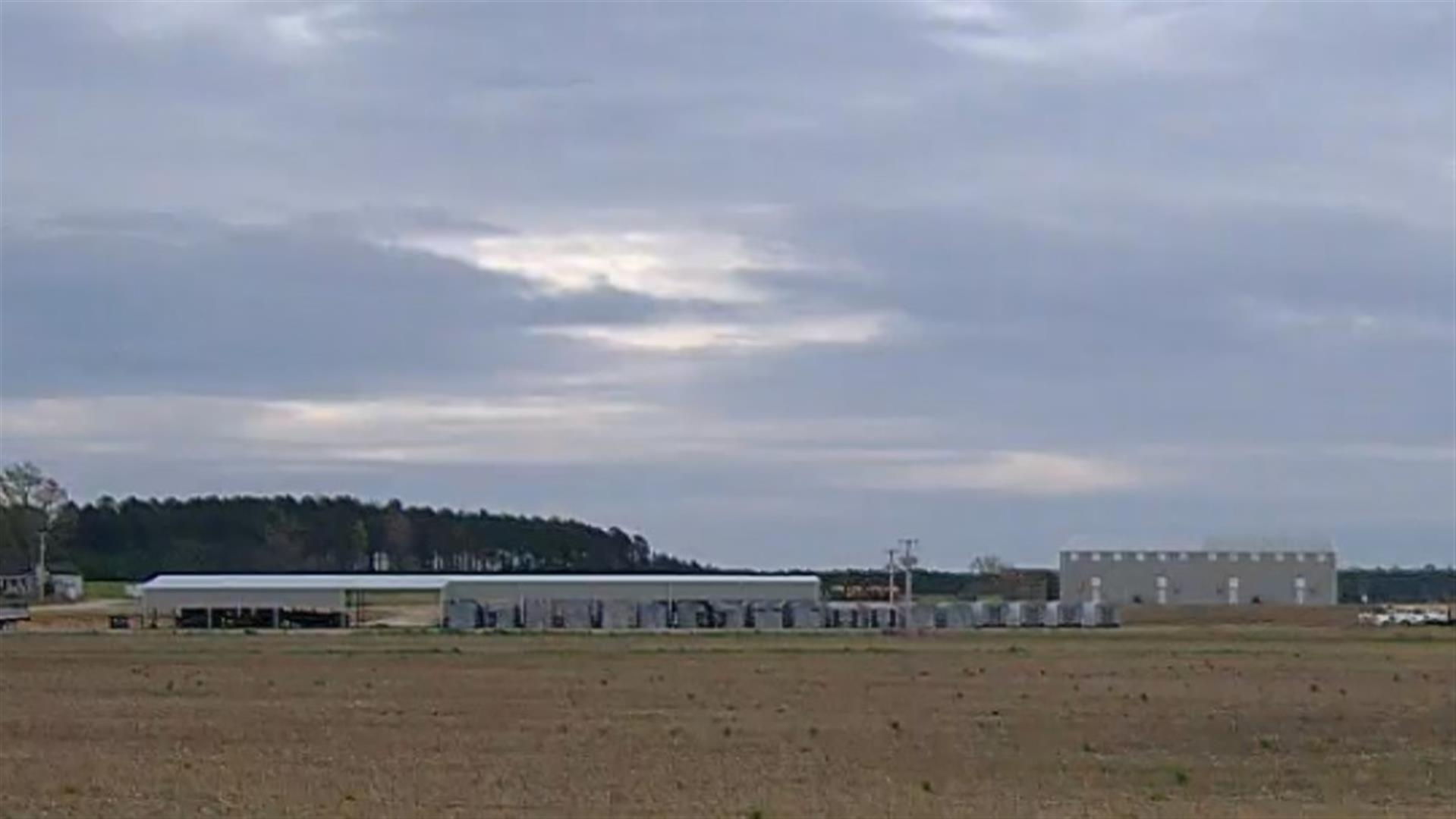 Photo 2
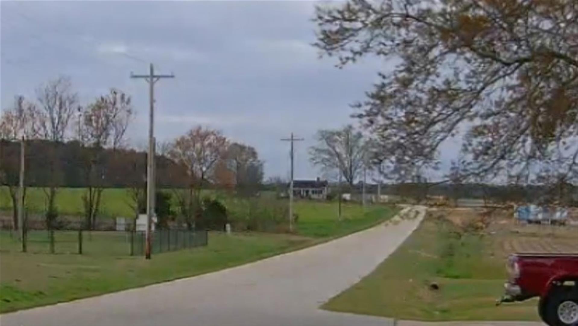
|
|
| Building
Sketch - NOTE: Sketches are updated the first day of every month. |
|
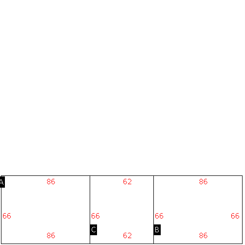
(Building 1) - Sketch for Parcel ID: 3755300809.000
NOTE: Sketches are updated the first day of every month.
 |
| Label |
Description |
Base SF |
Total SF |
| A |
SFR-1.0 STY |
1472.00 |
1472.00 |
| B |
PORCH-OPEN-FR |
128.00 |
128.00 |
| C |
PORCH-OPEN-FR |
256.00 |
256.00 |
| D |
PATIO-CONC |
64.00 |
.00 |
|
|
(Building 2) - Sketch for Parcel ID: 3755300809.000
NOTE: Sketches are updated the first day of every month.
 |
| Label |
Description |
Base SF |
Total SF |
| A |
WHSE |
5676.00 |
5676.00 |
| B |
WHSE |
5676.00 |
5676.00 |
| C |
CANOPY W/ SLAB |
4092.00 |
.00 |
|
|
|
|
|
| Map Acres |
95.92 |
| Tax District Note |
23 - C/SW/TOISNOT FD |
| Present-Use Info |
RURAL HOMESITE |
| Zoning Code |
AR |
| Zoning Desc |
AGRICUL-RESID 40M SF |
|
| Total Improvements Valuation
|
*Total Improvements Full Market Value $
|
**Total Improvements Assessed Value
|
786,297
|
786,297
|
*
Note - Market Value effective Date equal January 1, 2024, date of County’s most recent General
Reappraisal
** Note - If Assessed Value not equal Market Value then variance
resulting from formal appeal procedure |
|
| Land
Value Detail (Effective Date January 1, 2024, date
of County’s most recent General Reappraisal) |
Land
Full Value (LFV) $
|
Land
Present-Use Value (PUV) $ **
|
Land
Total Assessed Value $
|
172,834
|
96,525
|
96,525
|
| **
Note: If PUV equal LMV then parcel has
not qualified for present use program |
|
| Land
Detail (Effective Date January 1, 2024, date of County’s
most recent General Reappraisal) |
Rate Type |
Rate Code |
Description |
Quantity |
AC |
5010 |
RURAL HOMESITE PAVED |
1.000 |
|
|
|
.000 |
AC |
0121 |
RESIDUAL ACREAGE PAVED |
1.500 |
|
|
|
.000 |
AC |
5111 |
MKT OPEN LD PVD CLASS 1 |
33.100 |
LU |
5110 |
|
33.100 |
AC |
5211 |
MKT OPEN LD PVD CLASS 2 |
2.070 |
LU |
5210 |
|
2.070 |
AC |
5311 |
MKT OPEN LD PVD CLASS 3 |
14.500 |
LU |
5310 |
|
14.500 |
AC |
6111 |
MKT WOODS PVD CLASS 1 |
34.000 |
LU |
6110 |
|
34.000 |
AC |
6311 |
MKT WOODS PVD CLASS 3 |
9.750 |
LU |
6310 |
|
9.750 |
|
|
|
|
